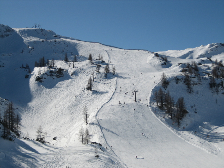


Portillo Storm Snowfall Total Passes 5m / 17 Feet
A snow storm that has now continued for nine days has taken Chilean ski resort Portillo to a snowfall total of 5.2 metres (17 feet) so far, with more snow forecast.

Next 4 days weather summary:Pioggia moderata (totale 17.0mm), più pesante Mercoledì pomeriggio. Caldo (max 20°C Giovedì pomeriggio, min 8°C Lunedì notte). Vento sarà generalmente leggero. | Giorni 5-7 Zauchensee sommario meteoPioggia moderata (totale 13.0mm), più pesante Domenica pomeriggio. Caldo (max 21°C Venerdì pomeriggio, min 12°C Sabato notte). Vento sarà generalmente leggero. | |||||||||||||||
Martedì 28 | Mercoledì 29 | Giovedì 30 | Venerdì 31 | Sabato 1 | ||||||||||||
notte | AM | PM | notte | AM | PM | notte | AM | PM | notte | AM | PM | notte | AM | PM | notte | |
rovesci pioggia | limpido | limpido | limpido | limpido | rischio temporale | rovesci pioggia | limpido | limpido | limpido | limpido | rovesci pioggia | rovesci pioggia | limpido | poche nuvole | pioggia leggera | |
km/h | ||||||||||||||||
Mappa neve |  |  |  |  |  |  | ||||||||||
— | — | — | — | — | — | — | — | — | — | — | — | — | — | — | — | |
mm | 1 | — | — | — | — | 12 | 4 | — | — | — | — | 1 | 3 | — | — | 4 |
max °C | 9 | 13 | 17 | 15 | 17 | 18 | 15 | 18 | 20 | 19 | 20 | 21 | 16 | 18 | 20 | 18 |
min °C | 8 | 10 | 15 | 13 | 15 | 13 | 14 | 16 | 19 | 16 | 17 | 18 | 14 | 17 | 19 | 12 |
chill °C | 6 | 9 | 15 | 13 | 15 | 13 | 14 | 16 | 19 | 16 | 17 | 18 | 13 | 17 | 19 | 12 |
Umido. % | 82 | 54 | 47 | 64 | 52 | 85 | 60 | 48 | 39 | 45 | 34 | 54 | 46 | 50 | 48 | 64 |
Zero termico m | 3800 | 4150 | 4500 | 4550 | 4450 | 4300 | 4350 | 4300 | 4550 | 4500 | 4600 | 4600 | 4700 | 4500 | 4600 | 4600 |
— | 5:37 | — | — | 5:39 | — | — | 5:41 | — | — | 5:41 | — | — | 5:43 | — | — | |
— | — | — | 8:45 | — | — | 8:45 | — | — | 8:43 | — | — | 8:42 | — | — | 8:40 | |
Diventa pro e intaglia:
Informazioni valanghe: European Avalanche Warning Services (EAWS)
Gli ultimi report della neve vicino a Zauchensee:
| La profondità maggiore della neve é: | 0 cm |
|---|---|
| La profondità minore della neve é: | 0 cm |
| Fresh snowfall depth: | — |
| Quando ha nevicato l'ultima volta? | 10 Jun 2026 |
0.0 | Giorni neve fresca Neve fresca, prevalentemente soleggiato, vento debole. |
|---|---|
0.0 | Giorni neve fresca Fresh snow, limited sun, any wind. |
0.0 | Giorni Bluebird Neve media, prevalentemente soleggiato, vento debole. |
La tabella sopra da le previsioni meteo per Zauchensee a specifiche altezze 2109 m. I nostri sofisticati modelli meteo ci consentono di fornire previsioni neve per la vetta, l'area intermedia e a valle delle stazioni sciistiche di Zauchensee. Per accedere alle previsioni meteo ad altre altezze, per spostarti usa tab sopra la tabella. Per una visione meteo piu' ampia , controlla la mappa meteo di Austria.
Clicca qui per leggere ulteriori informazioni sullo zero termico e il nostro sistema di prevedere le temperature.
Complessivamente 4.0 Basato su 17 voti e 10 recensioni
Excellent snow conditions at Zauchensee. Several cms of new, fresh powder on nicely groomed slopes. A few icy patches. Try the World Cup Run for a fantastic, challenging, continuous run from the top of the mountain to the base station.
Smitty da Germany scrive:
Excellent snow conditions at Zauchensee. Several cms of new, fresh powder on nicely groomed slopes. A few icy patches. Try the World Cup Run for a fantastic, challenging, continuous run from the top of the mountain to the base station.


 Nearest