|
Who created this site and why? We are a company based in South Wales, UK founded by Robert Davies, Rob McDonald and Nick Russill in 1997. The project was started to enhance our personal interest in snowboarding and grew from a forecast maps for New Zealand map into what you see today. Meet the snow forecast team here! Our expertise in writing software and interpreting large numerical datasets comes from our backgrounds as geoscientists. If you would like to find our more about our other activites, visit the websites at www.terradat.com. Robert Davies pioneered the original idea and writes the software behind the site and we have the technical backing of leading meterologists at leading research establishments. During the summer months we are to be found in the cool waters off the South Wales coast so look out for surf-forecast.com which is beginning to evolve in a similar way to snow-forecast. Where does your weather model come from? Although the actual snowfall forecasts are made using our computers at snow-forecast.com, the raw weather forecast data comes from the National Weather Service (NWS) in America; the largest organisation of its kind in the world. Serious weather forecasting requires massive computer power, vast expertise and an almost unlimited budget. Only a very few organisiations in the world can achieve this, arguably only two! If they are honset, most small weather companies derive their products from people like NOAA and ECMWF, and those that don't would probably become much more reliable if they did! To our credit we do much more than simply re-package NOAA products, but without them as a basis, our service couldn't exist at all. We use the Global Forecast System (GFS) weather models for our input data. For our purposes these are ideal, not only because they are detailed, reliable and frequently updated, but also, because they are intended for aviation planning. Thus, they contain accurate descriptions of how conditions vary with elevation. This provides the key to how we derive surface temperature over a wide range of altitudes using digital elevation models. When we combine this with preciptiation forecasts, we arrive at snowfall. How are the snow-forecasts made? Our Snow Forecast Maps are calculated by estimating the temperature on the surface (represented by a 1km digital elevation model) using lapse rates derived from pressure and temperature data. Snowfall is predicted wherever this same model forecasts precipitation falling onto ground that is expected to be below freezing on the basis of its altitude and the lapse rate at that point. The quantity of snow is given by the forecast accumulated precipitation, multiplied by a conservative snow:rain factor (8.0). In some areas, where dry and powdery snow tends to fall, such as central Otago in New Zealand, this factor can sometimes be as great as 12 or more which would lead to an underestimate in snow levels locally and better ski conditions. How often are the forecasts updated? Some people comment that the forecasts are not punctual; e.g. our midnight to 6am map of the Alps doesn't appear until about 7am!!! What people don't realise is that this problem is true of all weather forecasts (and our source – the NOAA model in the USA is quicker than most). The problem is that NOAA take 4 hours on average to calculate their global forecast and we take another 2–5 hours to apply the corrections for the world's topography to make a snowfall forecast. This means that our 0–6 hour forecasts are always out of date! We put them on the page anyway, so that people can see how we think the weather was at this time. Alternatively we could have just called the 6–12 hour forecast 0 to 6, and pretended that weather forecasts took no time to make, just like TV forecasters do! Why are some parts of the site no longer free? In fact the information that is available for free is more extensive than ever. We decided to adopt a subscription model for long range forecasts and superior services such as "snowfinder" after two seasons of hard going with respect to generating revenues from online advertisiers. All the money raised from our subscribers: — pays for our massive server and bandwidth overhead How can I get free membership? Become a Snow Reporter! You can get free membership if you live or work in a resort that is not covered by our daily snow reports. Note you must submit regular reports in order to maintain your free status to the premium areas of our site! What makes snow-forecast different from other weather sites? Normal weather forecasts don't tell you the temperature at the surface on the scale of mountains. Instead they either quote temperatures for towns or else for valleys. The usual rule of thumb about temperature falling 1 degree per 100m is a very poor approximation, as anyone who has used it will be aware. When we estimate temperature we do it much more rigorously than this. We calculate exactly what the temperature is at the surface, e.g. on the mountainside. For this we use very precise digital topographic information at 1km resolution. This makes our forecasts of WHERE and WHEN snow will fall very accurate, but see (link) "Why is do snow forecasts tend to underestimate snowfall?" to understand why we still have trouble predicting HOW MUCH will fall! I got a snow alert but there is no snow showing on the maps! This is because the forecasts are generated before the maps, normally first thing in the morning (GMT). The alerts will therefore always be more up to date until the maps have been generated. Because of the intense amount of CPU time to generate the maps, the US maps are normally uploaded in the afternoon (GMT). Another reason why the amount of snow/rain in an alert may differ slightly is because the alert weather is calculated using an exact point and elevation in our weather model. The maps, because of the amount of processing time required, are smoothed to 1, 2, 4 or more kilometer squares so the contours shown are more of an average value. Some areas such as Scotland, South California or North Island NZ are modelled on 1km beacuse of the relatively localised mountain zones and the high popularity. One day, when we find a big backer we will be able to model the entire world at very high resolution! Why are the maps / resort forecasts out of date? The problem of "old" imagery being displayed is limited to some users accessing snow-forecast via AOL or other ISP's who store local snapshots of popular websites to save bandwidth. Our data are updated twice daily and users should therefore ensure that the correct date is shown indicating the most recent page. The best way around this is to do a "forced refresh" of your browser by pressing <CNTRL +F5> on your keyboard. AOL is caching (accessing our pages, storing them locally, and then serving them from their "proxy server cache" to AOL users WITHOUT refreshing them from snow-forecast.com) our site and causing imagery latency problems. As part of the caching process, images are converted from their gif format into a proprietary AOL compression format, which can destroy the "animated" feature of some of our images. For more in depth information on what you can do to minimize the effects of AOL cache, including how to clear the cache (to always get the latest imagery) please visit: http://webmaster.info.aol.com/ External websites are welcome to link to snow-forecast pages (php / html), but NOT to use any of the jpeg or gif images. The official URL is http://www.snow-forecast.com There are some banners and buttons for you to use that can be downloaded here. I am having problems accessing member only pages The most common reason for this is that your browser security settings do not permit cookies that are essential for our membership scripts. Here is how you enable cookies in various internet browsers: How to Enable Cookies
These are days which we choose at random where all the members-only restrictions will be lifted from the entire site so non members can get a taste of what they are missing out on! You can also get a taste of member only premium content every day, but viewing one of the top 5 resort picks on the daily pick page that snows the best resorts with new snow, power reported, coldest etc. We hope you like what you see and will become a member! My membership has expired, how can I renew? This is easy! All you need to do is login to the member section at http://www.snow-forecast.com/login then click the link for renewing your membership. just choose the duration, ammend any personal details if you wish, then enter your credit card details on the secure web page. Any problems, contact us Why is less snow forecast for the top of the mountain? When the top elevation is above the predicted cloud base, there will be occasions where we forecast less snowfall at the top of the mountain than for lower down. This happens whenever the model predicts that View the difference in maps here: http://www.snow-forecast.com/cloud_correction_comparison.php Radiometric cooling ? a fix to overestimated temperatures Several members of the site have commented that in some parts of the World our forecast night time temperatures are higher than actually experienced. The reason for this is that we use "free-air" temps. By interpolating down we treat the ground like it's not there. In reality, at night, snow and dry sand radiate very large amounts of heat energy and so really close to the ground, say a few 10's of m, it can get much colder than the free-air temp, especially when it is clear and wind is light. So, how to fix it and make our temperature values more realistic?! Our weather model has a nominal "surface". We have back-calculated this reference Over part of the N Hemisphere, where the sun is shining (and light winds) the effect is positive, by 1 to 3 degs e.g. California, Alaska. Where it is night, especially where there is snow and/or sand it is strongly negative (-6 in S Africa, -2 in W OZ -4 in Andes (sun has We have calculated this discrepancy for every period and applied it to our forecasts – When it is cloudy and/or windy it will make no difference. Otherwise it will add some degs in the day (recall those sunny days when it can be warmer in the Alps than we predicted) and subtract some at night, sometimes as much as 10degs (the snow in the high Alpine resorts freezes every night when it is clear – even when the free-air freezing-level is at 5000m). The graph below taken from the resort of Thredbo, Australia at the end of July 2003 shows that at some points in this graph, the F-level is above the summit, but temperatures at |
|
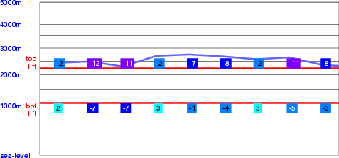
What do the Freezing Level (FL) graphs mean? The freezing level graphs show provide a graphical representation of the altitude (elevation) at which the temperature is a freezing point. Where this coicides with the elevation of the ground, any precipitation is likely to fall as snow and fresh water will freeze. The two upper and lower lines on the freezing level graphs indicate the top and bottom lifts in the ski resort that is being viewed. When the freezing level graph is above the elevation of the lift station, conditions can expected to be bad due to thawing. The numbers along the horizontal lines indicate the temperature for each forecast period at that elevation. Sometimes the temperature on the ground is below freezing, but the graph shows that the freezing level is higher.
The graph above shows an example of this. Somethimes the free-air freezing level can be at 2000m but at 0m it can still get below freezing at night without cooling a 2000m column of air (there simply isn't time). Free-air FL's are stable and, critically, it is the free-air FL that determines if snow or rain will fall. |
|
Web graphics attribution "Close" icon by Pavel Kozlov from www.flaticon.com, licensed by CC 3.0 BY. |
 Bad Gastein FL Graph 10/12/04
 Nearest