Ultimi 6 giorniScorri a sinistra per gli ultimi 6 giorniOra
Next 3 days weather summary:
Pioggia abbondante (totale 27.0mm), più pesante durante Venerdì notte. Caldo (max 23°C Giovedì pomeriggio, min 14°C Venerdì notte). Vento sarà generalmente leggero.
Giorni 4-6 St Johann-Alpendorf sommario meteo
Pioggia abbondante (totale 25.0mm), più pesante durante Sabato pomeriggio. Temperature moderate (max 16°C Sabato pomeriggio, min 8°C Domenica notte). Vento sarà generalmente leggero.
La tabella sopra da le previsioni meteo per St Johann-Alpendorf a specifiche altezze 1342 m. I nostri sofisticati modelli meteo ci consentono di fornire previsioni neve per la vetta, l'area intermedia e a valle delle stazioni sciistiche di St Johann-Alpendorf. Per accedere alle previsioni meteo ad altre altezze, per spostarti usa tab sopra la tabella. Per una visione meteo piu' ampia , controlla la mappa meteo di Austria.
Clicca qui per leggere ulteriori informazioni sullo zero termico e il nostro sistema di prevedere le temperature.
Recensioni dei visitatori di St Johann-Alpendorf
Complessivamente 4.4 Basato su 10 voti e 17 recensioni
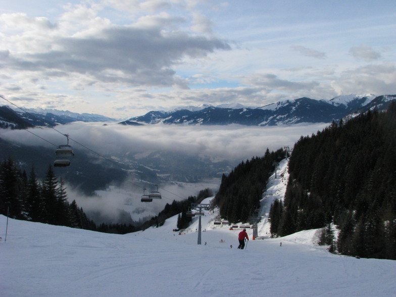
Here now at the peak week of the season. According to #WePowder, 5 million people headed to the Alps this week as the UK/Dutch and German half-term weeks created a perfect storm. Yes, it is crowded; avoid the bottom lifts between 08.45 and 09.45 and take a picnic as the restaurants are chaos, But the snow is the best in years; we've had two full on powder days and may even squeeze another in before the week is over. It is true that 80% of people go to 20% of the resorts, so we had a day in Grossarl (uncrowded) a day in Schladming (big enough to take the numbers) and will ski Hochkonig on "changeover" day, so it is possible to get some great runs in despite the crowds.
I can't comment on hotels but our 8 bed apartment in the Steakhouse Rauchkuchen at €750 per week is a bloody good deal. We're only 4 so plenty of room and usable kitchen.
Love Ski Amade and the Austrian Apres so much that we're buying in Flachau.
Off ski touring next week so may post an update.
Complessivamente: 4.4 Basato su 10 voti e 17 recensioni
Snowsure
4.3
Varietà di piste
4.7
Fuoripista
3.1
Paesaggio
4.7
Apres-Ski
4.0
Simon da United Kingdom scrive:
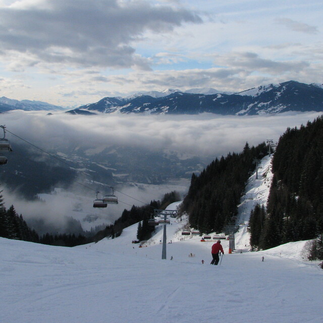
Here now at the peak week of the season. According to #WePowder, 5 million people headed to the Alps this week as the UK/Dutch and German half-term weeks created a perfect storm. Yes, it is crowded; avoid the bottom lifts between 08.45 and 09.45 and take a picnic as the restaurants are chaos, But the snow is the best in years; we've had two full on powder days and may even squeeze another in before the week is over. It is true that 80% of people go to 20% of the resorts, so we had a day in Grossarl (uncrowded) a day in Schladming (big enough to take the numbers) and will ski Hochkonig on "changeover" day, so it is possible to get some great runs in despite the crowds.
I can't comment on hotels but our 8 bed apartment in the Steakhouse Rauchkuchen at €750 per week is a bloody good deal. We're only 4 so plenty of room and usable kitchen.
Love Ski Amade and the Austrian Apres so much that we're buying in Flachau.
Off ski touring next week so may post an update.
Gratis Snow-Forecast.com weather widget per il tho sito
Il St Johann-Alpendorf widget meteo qui sotto è disponibile per essere incorporato su siti Web esterni a titolo gratuito. Esso fornisce un riepilogo giornaliero delle nostre St Johann-Alpendorf previsioni meteo neve e dati meteo. Basta andare alla pagina di configurazione e seguire 3 semplici passi per prendere il codice html personalizzato ed incollarlo nel tuo sito. È possibile scegliere l'elevazione di previsione di neve (vetta, metà o piede della montagna) e l'unità metrica/imperiale per le previsioni meteo neve adeguata al proprio sito Web Clicca qui per ottenere il codice


 Nearest