

America’s Next Indoor Snow Centre Takes Shape
Construction of a new indoor snow centre for skiers, boarders and tubers appears to be making good progress at Heritage Farm in Wayne County, West Virginia.

Next 4 days weather summary:Pioggia moderata (totale 10.0mm), più pesante Giovedì pomeriggio. Temperature moderate (max 10°C Mercoledì pomeriggio, min 5°C Giovedì mattina). Vento sarà generalmente leggero. | Giorni 5-7 Scheffau (SkiWelt) sommario meteoPioggia moderata (totale 19.0mm), più pesante Domenica pomeriggio. Temperature moderate (max 16°C Sabato pomeriggio, min 6°C Giovedì notte). Vento sarà generalmente leggero. | |||||||||||||||
Martedì 21 | Mercoledì 22 | Giovedì 23 | Venerdì 24 | Sabato 25 | ||||||||||||
notte | AM | PM | notte | AM | PM | notte | AM | PM | notte | AM | PM | notte | AM | PM | notte | |
poche nuvole | poche nuvole | nuvol- oso | rovesci pioggia | limpido | limpido | rovesci pioggia | rovesci pioggia | rischio temporale | rovesci pioggia | limpido | limpido | poche nuvole | limpido | limpido | pioggia leggera | |
km/h | ||||||||||||||||
Mappa neve |  |  |  |  |  |  | ||||||||||
— | — | — | — | — | — | — | — | — | — | — | — | — | — | — | — | |
mm | — | — | — | 3 | — | — | 1 | 2 | 4 | 4 | — | — | — | — | — | 3 |
max °C | 9 | 7 | 9 | 7 | 7 | 10 | 10 | 5 | 7 | 6 | 7 | 11 | 11 | 12 | 16 | 15 |
min °C | 7 | 7 | 7 | 6 | 6 | 9 | 6 | 5 | 6 | 6 | 6 | 9 | 10 | 11 | 15 | 10 |
chill °C | 5 | 6 | 4 | 4 | 4 | 7 | 2 | 1 | 2 | 3 | 4 | 8 | 9 | 9 | 15 | 10 |
Umido. % | 75 | 83 | 76 | 78 | 49 | 53 | 65 | 89 | 78 | 63 | 48 | 34 | 41 | 43 | 42 | 70 |
Zero termico m | 3400 | 3250 | 2900 | 2700 | 3100 | 3000 | 3050 | 2800 | 2800 | 2650 | 3050 | 3500 | 3700 | 3750 | 4000 | 3850 |
— | 5:33 | — | — | 5:35 | — | — | 5:37 | — | — | 5:37 | — | — | 5:39 | — | — | |
— | — | — | 8:59 | — | — | 8:58 | — | — | 8:57 | — | — | 8:55 | — | — | 8:54 | |
Diventa pro e intaglia:
Informazioni valanghe: European Avalanche Warning Services (EAWS)
Gli ultimi report della neve vicino a Scheffau (SkiWelt):
| La profondità maggiore della neve é: | — |
|---|---|
| La profondità minore della neve é: | — |
| Fresh snowfall depth: | — |
| Quando ha nevicato l'ultima volta? | 16 May 2026 |
0.0 | Giorni neve fresca Neve fresca, prevalentemente soleggiato, vento debole. |
|---|---|
0.0 | Giorni neve fresca Fresh snow, limited sun, any wind. |
0.0 | Giorni Bluebird Neve media, prevalentemente soleggiato, vento debole. |

La tabella sopra da le previsioni meteo per Scheffau (SkiWelt) a specifiche altezze 1957 m. I nostri sofisticati modelli meteo ci consentono di fornire previsioni neve per la vetta, l'area intermedia e a valle delle stazioni sciistiche di Scheffau (SkiWelt). Per accedere alle previsioni meteo ad altre altezze, per spostarti usa tab sopra la tabella. Per una visione meteo piu' ampia , controlla la mappa meteo di Austria.
Clicca qui per leggere ulteriori informazioni sullo zero termico e il nostro sistema di prevedere le temperature.
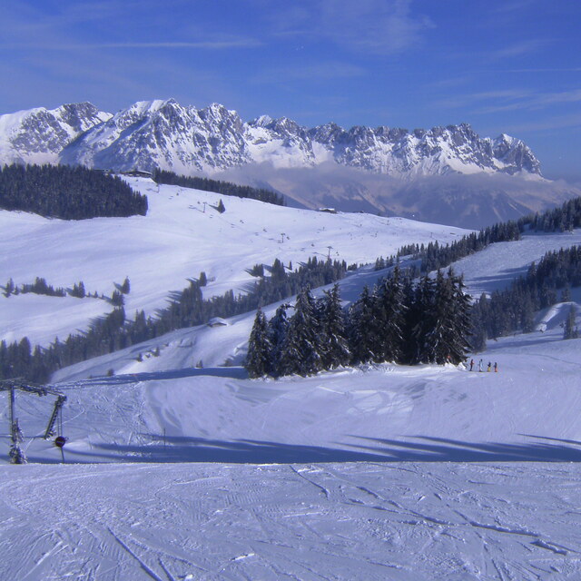
Il nome della localita' è scritto anche come Scheffau.
Complessivamente 3.8 Basato su 7 voti e 13 recensioni
Stayed at the Land Alpin which continues to serve up excellent food and is conveniently located. With the relatively mild weather over Christmas the rooms were far too hot though and even with the windows open and the radiator off it was too hot in the room at night. Snow not brilliant this year and we could not ski down to the gondola but with buses every 15 minutes, from outside the hotel, (except over lunch time) you never need to wait long for a bus. The gondola takes you up high and the snow up there was good up to about 2pm when it became slushy each day.
Graham W da United Kingdom scrive:
Stayed at the Land Alpin which continues to serve up excellent food and is conveniently located. With the relatively mild weather over Christmas the rooms were far too hot though and even with the windows open and the radiator off it was too hot in the room at night.
Snow not brilliant this year and we could not ski down to the gondola but with buses every 15 minutes, from outside the hotel, (except over lunch time) you never need to wait long for a bus. The gondola takes you up high and the snow up there was good up to about 2pm when it became slushy each day.
Leggi 12 più recensioni di Scheffau (SkiWelt) o invia la tua


 Nearest