

America’s Next Indoor Snow Centre Takes Shape
Construction of a new indoor snow centre for skiers, boarders and tubers appears to be making good progress at Heritage Farm in Wayne County, West Virginia.

Next 3 days weather summary:Pioggia moderata (totale 12.0mm), più pesante Giovedì pomeriggio. Temperature moderate (max 16°C Mercoledì pomeriggio, min 9°C Martedì notte). Vento sarà generalmente leggero. | Giorni 4-6 Scheffau (SkiWelt) sommario meteoPioggia abbondante (totale 30.0mm), più pesante durante Domenica pomeriggio. Caldo (max 22°C Sabato pomeriggio, min 10°C Venerdì mattina). Vento sarà generalmente leggero. | |||||||||||||||||
Martedì 21 | Mercoledì 22 | Giovedì 23 | Venerdì 24 | Sabato 25 | Domenica 26 | |||||||||||||
AM | PM | notte | AM | PM | notte | AM | PM | notte | AM | PM | notte | AM | PM | notte | AM | PM | notte | |
poche nuvole | poche nuvole | rovesci pioggia | limpido | limpido | rovesci pioggia | rovesci pioggia | rischio temporale | rovesci pioggia | limpido | limpido | poche nuvole | limpido | limpido | poche nuvole | rischio temporale | forte pioggia | pioggia moderata | |
km/h | ||||||||||||||||||
Mappa neve |  |  |  |  |  |  | ||||||||||||
— | — | — | — | — | — | — | — | — | — | — | — | — | — | — | — | — | — | |
mm | — | — | 2 | — | — | 1 | 2 | 4 | 3 | — | — | — | — | — | — | 3 | 19 | 8 |
max °C | 12 | 14 | 11 | 12 | 16 | 15 | 9 | 12 | 11 | 12 | 16 | 15 | 17 | 22 | 20 | 15 | 14 | 13 |
min °C | 10 | 13 | 9 | 9 | 15 | 10 | 9 | 11 | 10 | 10 | 15 | 13 | 15 | 20 | 16 | 14 | 14 | 11 |
chill °C | 10 | 12 | 9 | 9 | 15 | 9 | 8 | 10 | 10 | 10 | 15 | 13 | 15 | 20 | 16 | 13 | 13 | 11 |
Umido. % | 74 | 70 | 77 | 62 | 38 | 52 | 92 | 72 | 65 | 59 | 40 | 54 | 44 | 34 | 43 | 68 | 80 | 84 |
Zero termico m | 3250 | 2950 | 2700 | 3100 | 3000 | 3050 | 2750 | 2850 | 2750 | 3150 | 3500 | 3750 | 3850 | 3950 | 3850 | 3550 | 3400 | 3150 |
5:33 | — | — | 5:35 | — | — | 5:37 | — | — | 5:37 | — | — | 5:39 | — | — | 5:39 | — | — | |
— | — | 8:59 | — | — | 8:58 | — | — | 8:57 | — | — | 8:55 | — | — | 8:54 | — | — | 8:52 | |
Diventa pro e intaglia:
Informazioni valanghe: European Avalanche Warning Services (EAWS)
Gli ultimi report della neve vicino a Scheffau (SkiWelt):
| La profondità maggiore della neve é: | — |
|---|---|
| La profondità minore della neve é: | — |
| Fresh snowfall depth: | — |
| Quando ha nevicato l'ultima volta? | 16 May 2026 |
0.0 | Giorni neve fresca Neve fresca, prevalentemente soleggiato, vento debole. |
|---|---|
0.0 | Giorni neve fresca Fresh snow, limited sun, any wind. |
0.0 | Giorni Bluebird Neve media, prevalentemente soleggiato, vento debole. |

La tabella sopra da le previsioni meteo per Scheffau (SkiWelt) a specifiche altezze 1288 m. I nostri sofisticati modelli meteo ci consentono di fornire previsioni neve per la vetta, l'area intermedia e a valle delle stazioni sciistiche di Scheffau (SkiWelt). Per accedere alle previsioni meteo ad altre altezze, per spostarti usa tab sopra la tabella. Per una visione meteo piu' ampia , controlla la mappa meteo di Austria.
Clicca qui per leggere ulteriori informazioni sullo zero termico e il nostro sistema di prevedere le temperature.
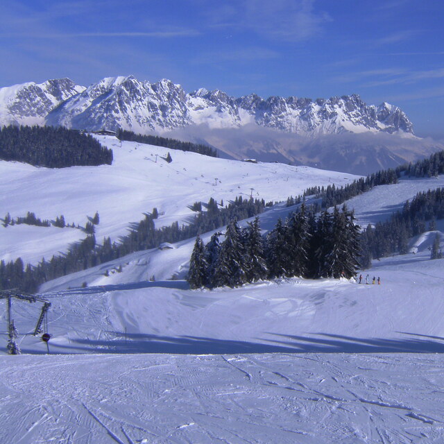
Il nome della localita' è scritto anche come Scheffau.
Complessivamente 3.8 Basato su 7 voti e 13 recensioni
The first time I went to Scheffau was March 2014. The snow wasn't great but the pisters had done a fantastic job. Having had a great holiday I went back for a weekend break in January and a family trip in March. Thankfully, the snow was much better this year! Scheffau is perfect for skiing the SkiWelt area as it's in the middle of the ski area. If you're travelling with children then this place is great, if it's their first time I would suggest the KinderKaiserland ski school as it's located at the top of the gondola and it's easy to come back during the day to see how they are getting on. If they have been before I would recommend ski School Ingrid Salvenmoser as it seemed quieter than the others and the groups are smaller. Having skied in France lots over the last 15-20 years it was refreshing coming back to Austria, so much cheaper than France and cleaner with picture postcard alpine buildings. Everytime I have stayed at the hotel kaiser in Tirol, I love this place, kids club in the evenings, fantastic food with free drink and it has everything you could wish for in a hotel. I've already booked up to go back next January and March!!
Richard B da United Kingdom scrive:
The first time I went to Scheffau was March 2014. The snow wasn't great but the pisters had done a fantastic job. Having had a great holiday I went back for a weekend break in January and a family trip in March. Thankfully, the snow was much better this year!
Scheffau is perfect for skiing the SkiWelt area as it's in the middle of the ski area. If you're travelling with children then this place is great, if it's their first time I would suggest the KinderKaiserland ski school as it's located at the top of the gondola and it's easy to come back during the day to see how they are getting on. If they have been before I would recommend ski School Ingrid Salvenmoser as it seemed quieter than the others and the groups are smaller. Having skied in France lots over the last 15-20 years it was refreshing coming back to Austria, so much cheaper than France and cleaner with picture postcard alpine buildings. Everytime I have stayed at the hotel kaiser in Tirol, I love this place, kids club in the evenings, fantastic food with free drink and it has everything you could wish for in a hotel. I've already booked up to go back next January and March!!
Leggi 12 più recensioni di Scheffau (SkiWelt) o invia la tua


 Nearest