

America’s Next Indoor Snow Centre Takes Shape
Construction of a new indoor snow centre for skiers, boarders and tubers appears to be making good progress at Heritage Farm in Wayne County, West Virginia.

Next 3 days weather summary:Pioggia leggera (totale 7.0mm), per lo più che cade Giovedì pomeriggio. Caldo (max 20°C Venerdì pomeriggio, min 6°C Giovedì notte). Vento sarà generalmente leggero. | Giorni 4-6 Patscherkofel sommario meteoPioggia abbondante (totale 20.0mm), più pesante durante Domenica pomeriggio. Caldo (max 25°C Sabato pomeriggio, min 10°C Domenica notte). Vento sarà generalmente leggero. | |||||||||||||||||
Mercoledì 22 | Giovedì 23 | Venerdì 24 | Sabato 25 | Domenica 26 | Lunedì 27 | |||||||||||||
AM | PM | notte | AM | PM | notte | AM | PM | notte | AM | PM | notte | AM | PM | notte | AM | PM | notte | |
limpido | limpido | poche nuvole | rovesci pioggia | rovesci pioggia | rovesci pioggia | limpido | limpido | poche nuvole | poche nuvole | limpido | rovesci pioggia | pioggia leggera | pioggia moderata | rovesci pioggia | limpido | poche nuvole | rovesci pioggia | |
km/h | ||||||||||||||||||
Mappa neve |  |  |  |  |  |  | ||||||||||||
— | — | — | — | — | — | — | — | — | — | — | — | — | — | — | — | — | — | |
mm | — | — | — | 1 | 3 | 3 | — | — | — | — | — | 3 | 4 | 6 | 6 | — | — | 1 |
max °C | 15 | 19 | 15 | 13 | 16 | 12 | 16 | 20 | 15 | 20 | 25 | 19 | 14 | 19 | 14 | 19 | 21 | 17 |
min °C | 9 | 19 | 8 | 11 | 15 | 6 | 9 | 19 | 9 | 13 | 24 | 12 | 14 | 17 | 10 | 13 | 21 | 12 |
chill °C | 9 | 19 | 8 | 11 | 15 | 5 | 9 | 19 | 9 | 13 | 24 | 11 | 14 | 17 | 10 | 13 | 21 | 12 |
Umido. % | 55 | 35 | 69 | 67 | 55 | 81 | 45 | 28 | 58 | 41 | 26 | 79 | 82 | 57 | 74 | 58 | 54 | 80 |
Zero termico m | 3150 | 3450 | 3200 | 3000 | 3050 | 2850 | 3400 | 3600 | 3900 | 3950 | 4300 | 4150 | 3650 | 3750 | 3450 | 3750 | 4100 | 4550 |
5:39 | — | — | 5:41 | — | — | 5:41 | — | — | 5:43 | — | — | 5:43 | — | — | 5:45 | — | — | |
— | — | 9:00 | — | — | 8:59 | — | — | 8:58 | — | — | 8:57 | — | — | 8:54 | — | — | 8:53 | |
Diventa pro e intaglia:
Informazioni valanghe: European Avalanche Warning Services (EAWS)
Gli ultimi report della neve vicino a Patscherkofel:
| La profondità maggiore della neve é: | 0 cm |
|---|---|
| La profondità minore della neve é: | 0 cm |
| Fresh snowfall depth: | — |
| Quando ha nevicato l'ultima volta? | 10 Jun 2026 |
0.0 | Giorni neve fresca Neve fresca, prevalentemente soleggiato, vento debole. |
|---|---|
0.0 | Giorni neve fresca Fresh snow, limited sun, any wind. |
0.0 | Giorni Bluebird Neve media, prevalentemente soleggiato, vento debole. |
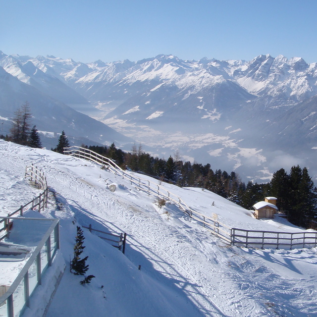
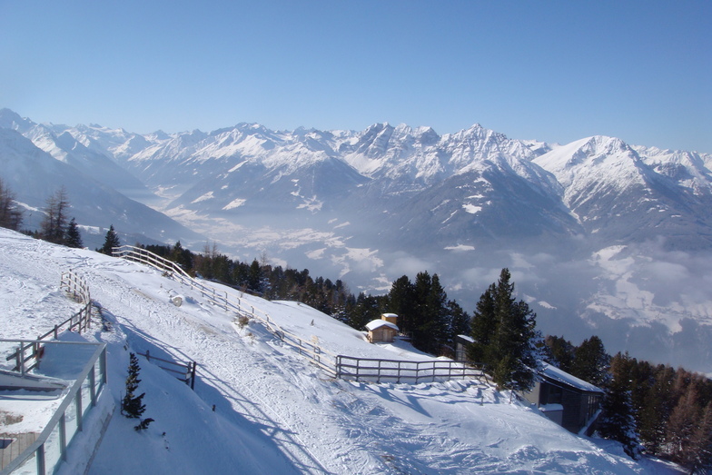
La tabella sopra da le previsioni meteo per Patscherkofel a specifiche altezze 1294 m. I nostri sofisticati modelli meteo ci consentono di fornire previsioni neve per la vetta, l'area intermedia e a valle delle stazioni sciistiche di Patscherkofel. Per accedere alle previsioni meteo ad altre altezze, per spostarti usa tab sopra la tabella. Per una visione meteo piu' ampia , controlla la mappa meteo di Austria.
Clicca qui per leggere ulteriori informazioni sullo zero termico e il nostro sistema di prevedere le temperature.
Complessivamente 3.8 Basato su 15 voti e 4 recensioni
This is the best resort for learning and practising for whole family. We love this region and all mountains but especially Patscherkofel. You can find there lots of different ways for skiing. Our family is going to PK in January again and I am absolutely sure there will be lots of fun. Our kids love this mountain because they can go and ski when parents want to stop and drink Glühwein. In Olex restaurant you can take some rest and still control what your kids are doing and how they are skiing. But if you are an advanced skier it could be a little boring for longer than a week. If you plan to ski all day long up-and-down, the mountain is quite small. I think also that the marking OlimpiaAbfahrt as red could be little deceptive because, in my opinion, there are parts that should be marked as black.
Hubert da Poland scrive:
This is the best resort for learning and practising for whole family. We love this region and all mountains but especially Patscherkofel. You can find there lots of different ways for skiing. Our family is going to PK in January again and I am absolutely sure there will be lots of fun. Our kids love this mountain because they can go and ski when parents want to stop and drink Glühwein. In Olex restaurant you can take some rest and still control what your kids are doing and how they are skiing.
But if you are an advanced skier it could be a little boring for longer than a week. If you plan to ski all day long up-and-down, the mountain is quite small.
I think also that the marking OlimpiaAbfahrt as red could be little deceptive because, in my opinion, there are parts that should be marked as black.


 Nearest