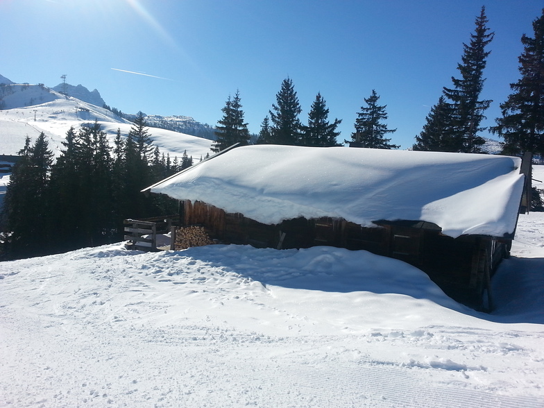


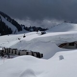
Portillo Re-Opens To Guests Arriving By Helicopter
Chile’s famous Portillo ski resort is reported to have re-opened to guests arriving by helicopter after being cut off by road for more than two weeks by over 6m/20 feet of snowfall.

Next 3 days weather summary:Pioggia abbondante (totale 23.0mm), più pesante durante Mercoledì notte. Caldo (max 24°C Lunedì pomeriggio, min 16°C Mercoledì mattina). Vento sarà generalmente leggero. | Giorni 4-6 Lofer sommario meteoPioggia abbondante (totale 36.0mm), più pesante durante Giovedì notte. Temperature moderate (max 19°C Giovedì pomeriggio, min 11°C Venerdì mattina). Vento sarà generalmente leggero. | ||||||||||||||||
Lun 3 | Martedì 4 | Mercoledì 5 | Giovedì 6 | Venerdì 7 | Sabato 8 | ||||||||||||
PM | notte | AM | PM | notte | AM | PM | notte | AM | PM | notte | AM | PM | notte | AM | PM | notte | |
rischio temporale | rovesci pioggia | limpido | poche nuvole | rovesci pioggia | rovesci pioggia | rischio temporale | rischio temporale | rischio temporale | rischio temporale | forte pioggia | pioggia moderata | rischio temporale | rovesci pioggia | limpido | rischio temporale | rovesci pioggia | |
km/h | |||||||||||||||||
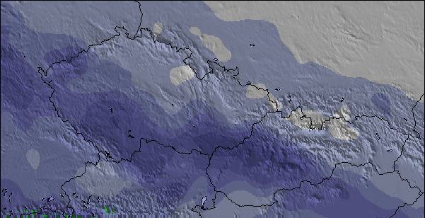
Mappa neve |  |  |  |  |  | 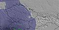 | |||||||||||
— | — | — | — | — | — | — | — | — | — | — | — | — | — | — | — | — | |
mm | 1 | 1 | — | — | 2 | 1 | 3 | 13 | 2 | 8 | 14 | 7 | 3 | 1 | — | 2 | 1 |
max °C | 24 | 20 | 21 | 23 | 22 | 18 | 20 | 19 | 18 | 19 | 15 | 11 | 13 | 13 | 14 | 16 | 15 |
min °C | 20 | 19 | 20 | 22 | 17 | 16 | 20 | 16 | 17 | 18 | 12 | 11 | 13 | 13 | 12 | 16 | 14 |
chill °C | 20 | 19 | 20 | 22 | 17 | 16 | 20 | 16 | 17 | 18 | 10 | 11 | 13 | 13 | 12 | 16 | 14 |
Umido. % | 49 | 45 | 47 | 47 | 55 | 71 | 65 | 83 | 70 | 66 | 90 | 97 | 88 | 84 | 77 | 71 | 70 |
Zero termico m | 4500 | 4500 | 4500 | 4550 | 4550 | 4500 | 4550 | 4500 | 4350 | 4350 | 4000 | 3800 | 4050 | 4050 | 3950 | 4050 | 4100 |
— | — | 5:48 | — | — | 5:50 | — | — | 5:52 | — | — | 5:52 | — | — | 5:54 | — | — | |
— | 8:40 | — | — | 8:39 | — | — | 8:37 | — | — | 8:37 | — | — | 8:35 | — | — | 8:34 | |
Diventa pro e intaglia:
Informazioni valanghe: European Avalanche Warning Services (EAWS)
Gli ultimi report della neve vicino a Lofer:
| La profondità maggiore della neve é: | 0 cm |
|---|---|
| La profondità minore della neve é: | 0 cm |
| Fresh snowfall depth: | — |
| Quando ha nevicato l'ultima volta? | 16 May 2026 |
0.0 | Giorni neve fresca Neve fresca, prevalentemente soleggiato, vento debole. |
|---|---|
0.0 | Giorni neve fresca Fresh snow, limited sun, any wind. |
0.0 | Giorni Bluebird Neve media, prevalentemente soleggiato, vento debole. |
La tabella sopra da le previsioni meteo per Lofer a specifiche altezze 1670 m. I nostri sofisticati modelli meteo ci consentono di fornire previsioni neve per la vetta, l'area intermedia e a valle delle stazioni sciistiche di Lofer. Per accedere alle previsioni meteo ad altre altezze, per spostarti usa tab sopra la tabella. Per una visione meteo piu' ampia , controlla la mappa meteo di Austria.
Clicca qui per leggere ulteriori informazioni sullo zero termico e il nostro sistema di prevedere le temperature.
Complessivamente 3.6 Basato su 14 voti e 5 recensioni
We love Lofer. Great family resort, not too many queues and missed it for the last couple of years :-( . Excellent for young kids to learn, as we started our 4,5 and 8 yr old a good few years back, and they were well catered for. Can't wait to return in 5 weeks time and excited about spending new year on the slopes. Such great locals and always made to feel welcome wherever you go - our favourite place to ski ... PS - don't share this with too many people, as it will just become another hectic resort.
Francis Family da United Kingdom scrive:
We love Lofer. Great family resort, not too many queues and missed it for the last couple of years :-( . Excellent for young kids to learn, as we started our 4,5 and 8 yr old a good few years back, and they were well catered for.
Can't wait to return in 5 weeks time and excited about spending new year on the slopes.
Such great locals and always made to feel welcome wherever you go - our favourite place to ski ...
PS - don't share this with too many people, as it will just become another hectic resort.

 Nearest