

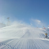
Portillo Storm Snowfall Total Passes 5m / 17 Feet
A snow storm that has now continued for nine days has taken Chilean ski resort Portillo to a snowfall total of 5.2 metres (17 feet) so far, with more snow forecast.

Next 3 days weather summary:Pioggia abbondante (totale 56.0mm), più pesante durante Sabato notte. Caldo (max 29°C Venerdì pomeriggio, min 16°C Sabato notte). Vento sarà generalmente leggero. | Giorni 4-6 Lofer sommario meteoPioggia abbondante (totale 20.0mm), più pesante durante Giovedì pomeriggio. Caldo (max 28°C Lunedì pomeriggio, min 16°C Martedì notte). Vento sarà generalmente leggero. | |||||||||||||||||
Giovedì 30 | Venerdì 31 | Sabato 1 | Domenica 2 | Lunedì 3 | Martedì 4 | |||||||||||||
AM | PM | notte | AM | PM | notte | AM | PM | notte | AM | PM | notte | AM | PM | notte | AM | PM | notte | |
poche nuvole | limpido | limpido | limpido | poche nuvole | pioggia moderata | poche nuvole | rischio temporale | rovesci pioggia | limpido | rischio temporale | rovesci pioggia | poche nuvole | nuvol- oso | rovesci pioggia | poche nuvole | pioggia moderata | rovesci pioggia | |
km/h | ||||||||||||||||||
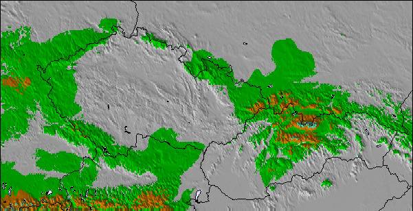
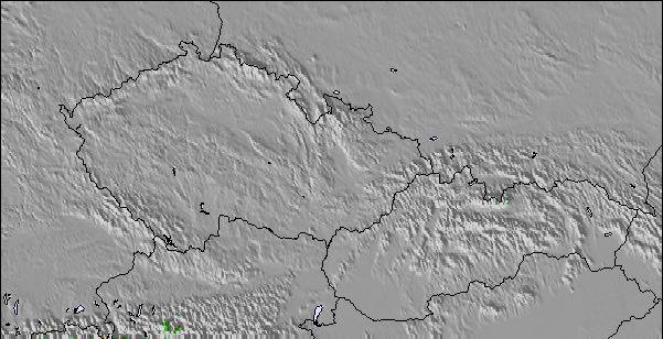
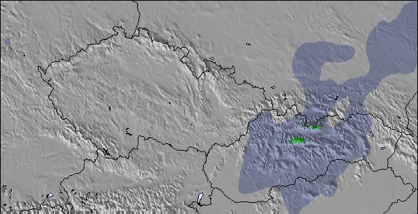
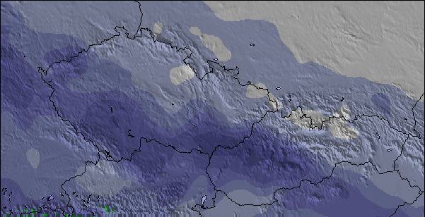
Mappa neve |  |  |  |  |  |  | ||||||||||||
— | — | — | — | — | — | — | — | — | — | — | — | — | — | — | — | — | — | |
mm | — | — | — | — | — | 9 | — | 2 | 45 | — | 1 | 2 | — | — | 1 | — | 8 | 8 |
max °C | 25 | 28 | 25 | 26 | 29 | 23 | 23 | 24 | 18 | 22 | 25 | 22 | 25 | 28 | 25 | 24 | 26 | 18 |
min °C | 23 | 27 | 21 | 23 | 26 | 17 | 20 | 22 | 16 | 19 | 22 | 22 | 23 | 27 | 19 | 20 | 20 | 16 |
chill °C | 23 | 27 | 21 | 23 | 26 | 17 | 20 | 22 | 16 | 19 | 22 | 22 | 23 | 27 | 19 | 20 | 20 | 16 |
Umido. % | 43 | 30 | 54 | 37 | 38 | 71 | 51 | 66 | 71 | 54 | 64 | 56 | 40 | 40 | 44 | 49 | 75 | 58 |
Zero termico m | 4300 | 4550 | 4450 | 4600 | 4650 | 4500 | 4300 | 4350 | 4150 | 4450 | 4600 | 4550 | 4550 | 4600 | 4600 | 4450 | 4250 | 4050 |
5:43 | — | — | 5:43 | — | — | 5:45 | — | — | 5:47 | — | — | 5:48 | — | — | 5:48 | — | — | |
— | — | 8:46 | — | — | 8:45 | — | — | 8:44 | — | — | 8:43 | — | — | 8:40 | — | — | 8:39 | |
Diventa pro e intaglia:
Informazioni valanghe: European Avalanche Warning Services (EAWS)
Gli ultimi report della neve vicino a Lofer:
| La profondità maggiore della neve é: | 0 cm |
|---|---|
| La profondità minore della neve é: | 0 cm |
| Fresh snowfall depth: | — |
| Quando ha nevicato l'ultima volta? | 16 May 2026 |
0.0 | Giorni neve fresca Neve fresca, prevalentemente soleggiato, vento debole. |
|---|---|
0.0 | Giorni neve fresca Fresh snow, limited sun, any wind. |
0.0 | Giorni Bluebird Neve media, prevalentemente soleggiato, vento debole. |
La tabella sopra da le previsioni meteo per Lofer a specifiche altezze 1155 m. I nostri sofisticati modelli meteo ci consentono di fornire previsioni neve per la vetta, l'area intermedia e a valle delle stazioni sciistiche di Lofer. Per accedere alle previsioni meteo ad altre altezze, per spostarti usa tab sopra la tabella. Per una visione meteo piu' ampia , controlla la mappa meteo di Austria.
Clicca qui per leggere ulteriori informazioni sullo zero termico e il nostro sistema di prevedere le temperature.
Complessivamente 3.6 Basato su 14 voti e 5 recensioni
Just got back from a great week's skiing in Lofer. Have to agree with previous posts, made for families. Only negative is our experience on the four man lift, arriving before the 4pm closing time, found the station closed! After protest we were allowed access ( 2 children included ), if this hadn't been the case a long hike up the mountain would have faced us. Thought this would have been a one off but the following day we arrived at 3:45 and the lads were cliosing up!! The lazy, uncaring attitude of the lift staff apart, an ideal resort for families ( just don't ski till the death!)
Ian unsworth da United Kingdom scrive:
Just got back from a great week's skiing in Lofer. Have to agree with previous posts, made for families. Only negative is our experience on the four man lift, arriving before the 4pm closing time, found the station closed! After protest we were allowed access ( 2 children included ), if this hadn't been the case a long hike up the mountain would have faced us. Thought this would have been a one off but the following day we arrived at 3:45 and the lads were cliosing up!!
The lazy, uncaring attitude of the lift staff apart, an ideal resort for families ( just don't ski till the death!)

 Nearest