

America’s Next Indoor Snow Centre Takes Shape
Construction of a new indoor snow centre for skiers, boarders and tubers appears to be making good progress at Heritage Farm in Wayne County, West Virginia.

Next 4 days weather summary:Pioggia abbondante (totale 34.0mm), più pesante durante Giovedì pomeriggio. Caldo (max 21°C Mercoledì pomeriggio, min 8°C Martedì notte). Vento sarà generalmente leggero. | Giorni 5-7 Alleghe sommario meteoPioggia moderata (totale 12.0mm), più pesante Domenica pomeriggio. Caldo (max 22°C Sabato pomeriggio, min 8°C Giovedì notte). Vento sarà generalmente leggero. | |||||||||||||||
Martedì 21 | Mercoledì 22 | Giovedì 23 | Venerdì 24 | Sabato 25 | ||||||||||||
notte | AM | PM | notte | AM | PM | notte | AM | PM | notte | AM | PM | notte | AM | PM | notte | |
rovesci pioggia | rischio temporale | rischio temporale | rovesci pioggia | limpido | rovesci pioggia | pioggia leggera | nuvol- oso | rischio temporale | rovesci pioggia | limpido | limpido | poche nuvole | limpido | rischio temporale | pioggia leggera | |
km/h | ||||||||||||||||
Mappa neve |  |  |  |  |  |  | ||||||||||
— | — | — | — | — | — | — | — | — | — | — | — | — | — | — | — | |
mm | 6 | 3 | 12 | 5 | — | 1 | 4 | — | 3 | 1 | — | — | — | — | 1 | 2 |
max °C | 17 | 18 | 19 | 15 | 18 | 21 | 16 | 19 | 20 | 15 | 18 | 21 | 15 | 20 | 22 | 17 |
min °C | 12 | 15 | 17 | 8 | 13 | 21 | 11 | 14 | 19 | 8 | 13 | 21 | 11 | 15 | 20 | 13 |
chill °C | 12 | 15 | 17 | 7 | 13 | 21 | 11 | 14 | 19 | 7 | 13 | 21 | 11 | 15 | 20 | 13 |
Umido. % | 84 | 80 | 74 | 84 | 49 | 47 | 80 | 47 | 50 | 81 | 36 | 46 | 90 | 62 | 68 | 98 |
Zero termico m | 3700 | 3650 | 3550 | 3350 | 3100 | 3750 | 3450 | 3300 | 3500 | 3000 | 3100 | 3850 | 3650 | 3650 | 3950 | 3700 |
— | 5:39 | — | — | 5:39 | — | — | 5:41 | — | — | 5:43 | — | — | 5:43 | — | — | |
— | — | — | 8:55 | — | — | 8:54 | — | — | 8:53 | — | — | 8:52 | — | — | 8:52 | |
Diventa pro e intaglia:
Informazioni valanghe: European Avalanche Warning Services (EAWS)
Gli ultimi report della neve vicino a Alleghe:
| La profondità maggiore della neve é: | 0 cm |
|---|---|
| La profondità minore della neve é: | 0 cm |
| Fresh snowfall depth: | — |
| Quando ha nevicato l'ultima volta? | 16 May 2026 |
0.0 | Giorni neve fresca Neve fresca, prevalentemente soleggiato, vento debole. |
|---|---|
0.0 | Giorni neve fresca Fresh snow, limited sun, any wind. |
0.0 | Giorni Bluebird Neve media, prevalentemente soleggiato, vento debole. |

La tabella sopra da le previsioni meteo per Alleghe a specifiche altezze 1000 m. I nostri sofisticati modelli meteo ci consentono di fornire previsioni neve per la vetta, l'area intermedia e a valle delle stazioni sciistiche di Alleghe. Per accedere alle previsioni meteo ad altre altezze, per spostarti usa tab sopra la tabella. Per una visione meteo piu' ampia , controlla la mappa meteo di Italy.
Clicca qui per leggere ulteriori informazioni sullo zero termico e il nostro sistema di prevedere le temperature.
Complessivamente 3.7 Basato su 20 voti e 4 recensioni
I have come to realize that it depends on what you like. Some folk like skiing in purpose built French ski resorts where you can put your skis on at the back door of your catered chalet and clock up mile after mile of piste until you return to a bar, exhausted, where a bar maid who comes from Wolverhampton or Liverpool charges you 10 Euros to drink your beer out of a plastic beaker. It's all OK because you've only paid £300 for your holiday which will include transfers. The Dolomites offer something totally different. They are stunningly beautiful mountains that turn a pink-red colour when the sun goes down. Around their bases are a collection of Tyrolian villages so I can't just talk about Alleghe without mentioning everything else on offer, besides another reviewer has done a great job of describing this 'little gem' of a place. The Dolomiti Superski lift pass is the largest in the world and links the many villages that are located along the passes of what is now a UNESCO world heritage site. There are endless miles of unbelievably beautiful scenery which can be explored along the many pistes and trails that make up the network. Gorgeous little log cabins and mountain huts offer an array of mouth watering dishes and you can eat fabulously and drink your beer, served by a beauty who will definitely not have originated from anywhere in the UK, all for the same 10 Euros and I have never received my beverage in a plastic cup! I have even been collected from the side of the piste though by a horse and sleigh - to be escorted to the most delightful place to dine on fresh pasta and good red wine. The Freeriding options are sensational. I recently bought a book written by Francesco Tremolada listing over 100 off-piste itineraries in the region including classic routes like the Val de Mezdi and it's all translated into English. Incidentally, he offers guiding which I would recommend. So, where does Alleghe fit into this paradise that has been overlooked by so many Brits? Well, right in the middle of it, if you have a car. The Alleghe ski area offers 80 kms of piste underneath the Civetta mountain, with views to Mount Pelmo. The area is also know as Civetta ski and offers night skiing in the Zoldon Valley. You can drive 20 minutes and be in Malga which directly accesses the Marmalada glacier and Arabba. Arabba itself is 30 minutes drive away and you are straight in to the Sella Ronda ski circuit. Cortina is 40 minutes and Venice airport is under two hours. It is a nice idea to extend your holiday to take in the sights of the famous city. The World War 1 ski tour passes through Alleghe and takes an entire day to complete. There are many more well-signed tours which take a day to complete and you never ski the same run or take the same lift twice! For people who like to clock up the miles of piste skiing this is a perfect opportunity and your electronic lift pass keeps a record which you can check up on when you get home. Finally, there are more snow cannons in the Dolomites than anywhere else in the world so the pistes are always in great condition. Probably over 50% of all the runs fall within the tree line so on a bad visibility day you can always find a place where you can see. OK, you might not be able to put your skis on at the door of your chalet but I think that I can live with that in such a wonderful winter environment.
Ben Bland da United Kingdom scrive:
I have come to realize that it depends on what you like.
Some folk like skiing in purpose built French ski resorts where you can put your skis on at the back door of your catered chalet and clock up mile after mile of piste until you return to a bar, exhausted, where a bar maid who comes from Wolverhampton or Liverpool charges you 10 Euros to drink your beer out of a plastic beaker. It's all OK because you've only paid £300 for your holiday which will include transfers.
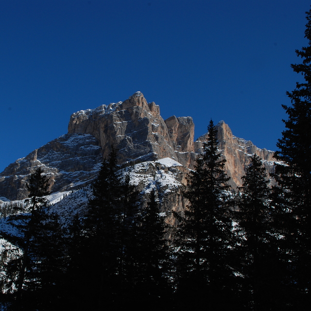
The Dolomites offer something totally different. They are stunningly beautiful mountains that turn a pink-red colour when the sun goes down. Around their bases are a collection of Tyrolian villages so I can't just talk about Alleghe without mentioning everything else on offer, besides another reviewer has done a great job of describing this 'little gem' of a place.
The Dolomiti Superski lift pass is the largest in the world and links the many villages that are located along the passes of what is now a UNESCO world heritage site. There are endless miles of unbelievably beautiful scenery which can be explored along the many pistes and trails that make up the network. Gorgeous little log cabins and mountain huts offer an array of mouth watering dishes and you can eat fabulously and drink your beer, served by a beauty who will definitely not have originated from anywhere in the UK, all for the same 10 Euros and I have never received my beverage in a plastic cup! I have even been collected from the side of the piste though by a horse and sleigh - to be escorted to the most delightful place to dine on fresh pasta and good red wine.
The Freeriding options are sensational. I recently bought a book written by Francesco Tremolada listing over 100 off-piste itineraries in the region including classic routes like the Val de Mezdi and it's all translated into English. Incidentally, he offers guiding which I would recommend.
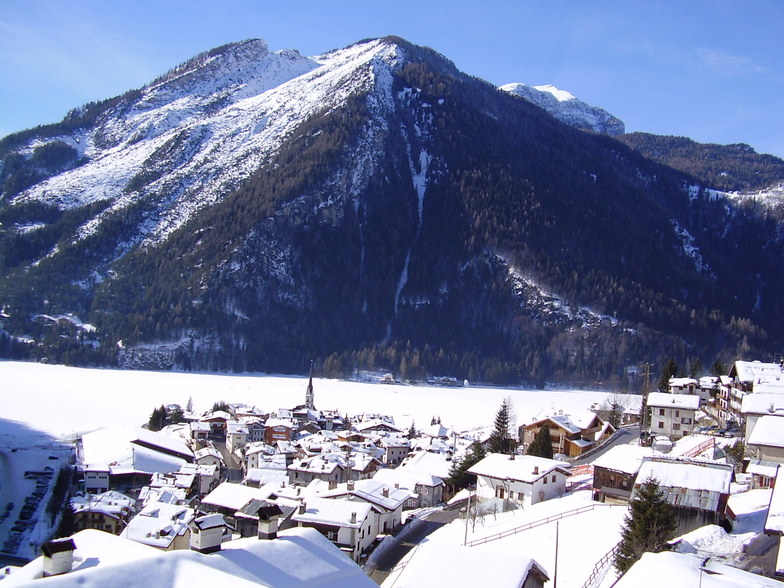
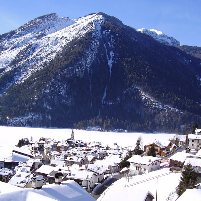
So, where does Alleghe fit into this paradise that has been overlooked by so many Brits? Well, right in the middle of it, if you have a car. The Alleghe ski area offers 80 kms of piste underneath the Civetta mountain, with views to Mount Pelmo. The area is also know as Civetta ski and offers night skiing in the Zoldon Valley. You can drive 20 minutes and be in Malga which directly accesses the Marmalada glacier and Arabba. Arabba itself is 30 minutes drive away and you are straight in to the Sella Ronda ski circuit. Cortina is 40 minutes and Venice airport is under two hours. It is a nice idea to extend your holiday to take in the sights of the famous city.
The World War 1 ski tour passes through Alleghe and takes an entire day to complete. There are many more well-signed tours which take a day to complete and you never ski the same run or take the same lift twice! For people who like to clock up the miles of piste skiing this is a perfect opportunity and your electronic lift pass keeps a record which you can check up on when you get home.
Finally, there are more snow cannons in the Dolomites than anywhere else in the world so the pistes are always in great condition. Probably over 50% of all the runs fall within the tree line so on a bad visibility day you can always find a place where you can see.
OK, you might not be able to put your skis on at the door of your chalet but I think that I can live with that in such a wonderful winter environment.


 Nearest