|
(266 m — 384 m)
|
|
|
|
|

|

|

|
|
|
|
|
|
Stazione intermedia 325 m
|
|
4500 m
|
4650 m
|
4300 m
|
4150 m
|
4350 m
|
4500 m
|
4800 m
|
|
|
(305 m — 419 m)
|
|
|
|
|
|
|

|

|
|
|
|
|
|
Stazione intermedia 362 m
|
|
4550 m
|
4250 m
|
3700 m
|
3500 m
|
4100 m
|
4450 m
|
4650 m
|
|
|
(465 m — 521 m)
|
|
|
|
|
|
|
|
|
|
|
|
|
|
Stazione intermedia 493 m
|
|
4350 m
|
4350 m
|
3400 m
|
3400 m
|
4000 m
|
4250 m
|
4400 m
|
|
|
(249 m — 389 m)
|
|
|
|
|
|
|
|
|
|
|
|
|
|
Stazione intermedia 319 m
|
|
4450 m
|
4400 m
|
3900 m
|
3800 m
|
4250 m
|
4450 m
|
4750 m
|
|
|
(396 m — 503 m)
|
|
|
|
|
|
|
|
|
|
|
|
|
|
Stazione intermedia 450 m
|
|
4500 m
|
4100 m
|
3350 m
|
3350 m
|
4100 m
|
4450 m
|
4500 m
|
|
|
(305 m — 381 m)
|
|
|
|
|
|
|
|
|
|
|
|
|
|
Stazione intermedia 343 m
|
|
4450 m
|
4400 m
|
3900 m
|
3850 m
|
4200 m
|
4450 m
|
4800 m
|
|
|
(151 m — 303 m)
|
|
|
|
|
|
|
|
|
|
|
|
|
|
Stazione intermedia 227 m
|
|
4500 m
|
4450 m
|
3950 m
|
3850 m
|
4250 m
|
4450 m
|
4850 m
|
|
|
(265 m — 330 m)
|
|
|
|
|
|
|
|
|
|
|
|
|
|
Stazione intermedia 298 m
|
|
4450 m
|
4650 m
|
4300 m
|
4150 m
|
4350 m
|
4500 m
|
4750 m
|
|
|
(379 m — 592 m)
|
|
|
|
|
|
|
|
|
|
|
|
|
|
Stazione intermedia 486 m
|
|
4450 m
|
4350 m
|
3650 m
|
3450 m
|
4050 m
|
4400 m
|
4600 m
|
|
|
(243 m — 305 m)
|
|
|
|
|
|
|
|
|
|
|
|
|
|
Stazione intermedia 274 m
|
|
4450 m
|
4550 m
|
4200 m
|
4000 m
|
4300 m
|
4450 m
|
4850 m
|
|
|
(244 m — 305 m)
|
|
|
|
|
|
|

|
|
|
|
|
|
|
Stazione intermedia 274 m
|
|
4450 m
|
4550 m
|
4100 m
|
4000 m
|
4300 m
|
4400 m
|
4850 m
|
|
|
(181 m — 344 m)
|
|
|
|
|
|
|
|
|
|
|
|
|
|
Stazione intermedia 262 m
|
|
4600 m
|
4200 m
|
3900 m
|
3700 m
|
4150 m
|
4450 m
|
4800 m
|
|
|
(266 m — 347 m)
|
|
|
|
|
|
|
|
|
|
|
|
|
|
Stazione intermedia 306 m
|
|
4450 m
|
4350 m
|
3800 m
|
3750 m
|
4150 m
|
4450 m
|
4700 m
|
|
|
(265 m — 331 m)
|
|
|
|
|
|
|
|
|
|
|
|
|
|
Stazione intermedia 298 m
|
|
4450 m
|
4550 m
|
4000 m
|
3900 m
|
4250 m
|
4400 m
|
4800 m
|
|
|
(363 m — 396 m)
|
|
|
|
|
|
|
|
|
|
|
|
|
|
Stazione intermedia 380 m
|
|
4450 m
|
4350 m
|
3650 m
|
3450 m
|
4050 m
|
4400 m
|
4600 m
|
|
|
(427 m — 539 m)
|
|
|
|
|
|
|
|
|
|
|
|
|
|
Stazione intermedia 483 m
|
|
4500 m
|
3850 m
|
3100 m
|
3400 m
|
4150 m
|
4350 m
|
4300 m
|
|
|
(286 m — 366 m)
|
|
|
|
|
|
|
|
|
|
|
|
|
|
Stazione intermedia 326 m
|
|
4550 m
|
4000 m
|
3300 m
|
3500 m
|
4150 m
|
4550 m
|
4500 m
|
|
|
(262 m — 354 m)
|
|
|
|
|
|
|
|

|
|
|
|
|
|
Stazione intermedia 308 m
|
|
4500 m
|
4500 m
|
4100 m
|
4050 m
|
4350 m
|
4450 m
|
4900 m
|
|
|
(411 m — 533 m)
|
|
|
|
|
|
|
|
|
|
|

|
|
|
Stazione intermedia 472 m
|
|
4450 m
|
3900 m
|
3150 m
|
3350 m
|
4000 m
|
4350 m
|
4150 m
|
|
|
(82 m — 152 m)
|
|
|
|
|
|
|
|
|
|
|
|
|
|
Stazione intermedia 117 m
|
|
4450 m
|
4650 m
|
4300 m
|
4200 m
|
4300 m
|
4500 m
|
4700 m
|
|
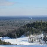
 Sci USA - Wisconsin


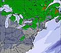


 Prossimo7 giorni di previsioni meteo.
 Nearest