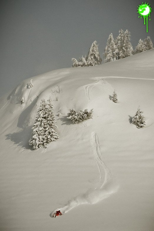


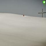
Portillo Storm Snowfall Total Passes 5m / 17 Feet
A snow storm that has now continued for nine days has taken Chilean ski resort Portillo to a snowfall total of 5.2 metres (17 feet) so far, with more snow forecast.

Next 3 days weather summary:Pioggia leggera (totale 4.0mm), per lo più che cade Mercoledì mattina. Caldo (max 22°C Giovedì pomeriggio, min 14°C Mercoledì notte). Vento sarà generalmente leggero. | Giorni 4-6 Warth-Schröcken sommario meteoPioggia moderata (totale 15.0mm), più pesante Domenica pomeriggio. Caldo (max 22°C Venerdì pomeriggio, min 14°C Venerdì notte). Vento sarà generalmente leggero. | ||||||||||||||||
Mar 28 | Mercoledì 29 | Giovedì 30 | Venerdì 31 | Sabato 1 | Domenica 2 | ||||||||||||
PM | notte | AM | PM | notte | AM | PM | notte | AM | PM | notte | AM | PM | notte | AM | PM | notte | |
limpido | limpido | rovesci pioggia | poche nuvole | rovesci pioggia | limpido | limpido | poche nuvole | limpido | nuvol- oso | rovesci pioggia | poche nuvole | rischio temporale | rovesci pioggia | limpido | pioggia leggera | rovesci pioggia | |
km/h | |||||||||||||||||
Mappa neve |  |  |  |  |  |  | |||||||||||
— | — | — | — | — | — | — | — | — | — | — | — | — | — | — | — | — | |
mm | — | — | 2 | — | 2 | — | — | — | — | — | 2 | — | 4 | 2 | — | 5 | 2 |
max °C | 19 | 17 | 18 | 19 | 17 | 20 | 22 | 21 | 21 | 22 | 18 | 17 | 17 | 16 | 18 | 20 | 16 |
min °C | 18 | 15 | 15 | 18 | 14 | 17 | 21 | 16 | 17 | 22 | 14 | 16 | 15 | 15 | 16 | 14 | 15 |
chill °C | 18 | 15 | 15 | 18 | 14 | 17 | 21 | 16 | 17 | 22 | 13 | 16 | 15 | 15 | 16 | 14 | 15 |
Umido. % | 46 | 67 | 51 | 60 | 50 | 30 | 27 | 49 | 38 | 39 | 61 | 53 | 64 | 61 | 46 | 83 | 56 |
Zero termico m | 4550 | 4450 | 4300 | 4450 | 4400 | 4500 | 4700 | 4600 | 4650 | 4750 | 4500 | 4350 | 4500 | 4550 | 4550 | 4550 | 4650 |
— | — | 5:52 | — | — | 5:54 | — | — | 5:54 | — | — | 5:56 | — | — | 5:58 | — | — | |
— | 8:58 | — | — | 8:57 | — | — | 8:55 | — | — | 8:53 | — | — | 8:52 | — | — | 8:52 | |
Diventa pro e intaglia:
Informazioni valanghe: European Avalanche Warning Services (EAWS)
Gli ultimi report della neve vicino a Warth-Schröcken:
| La profondità maggiore della neve é: | 0 cm |
|---|---|
| La profondità minore della neve é: | 0 cm |
| Fresh snowfall depth: | — |
| Quando ha nevicato l'ultima volta? | 18 May 2026 |
0.0 | Giorni neve fresca Neve fresca, prevalentemente soleggiato, vento debole. |
|---|---|
0.0 | Giorni neve fresca Fresh snow, limited sun, any wind. |
0.0 | Giorni Bluebird Neve media, prevalentemente soleggiato, vento debole. |
La tabella sopra da le previsioni meteo per Warth-Schröcken a specifiche altezze 2055 m. I nostri sofisticati modelli meteo ci consentono di fornire previsioni neve per la vetta, l'area intermedia e a valle delle stazioni sciistiche di Warth-Schröcken. Per accedere alle previsioni meteo ad altre altezze, per spostarti usa tab sopra la tabella. Per una visione meteo piu' ampia , controlla la mappa meteo di Austria.
Clicca qui per leggere ulteriori informazioni sullo zero termico e il nostro sistema di prevedere le temperature.
Il nome della localita' è scritto anche come Warth-Schroecken.
Complessivamente 3.5 Basato su 6 voti e 1 recensione
My wife and I originally skied in Warth-Schröcken in March 2014 when we made the trek across from St Christoph a couple of times. We liked the resort and the runs so decided to spend a full week there this January. Although the skiing, in Warth, is rather limited, there’s enough to keep a competent intermediate happy for a couple of days. The black runs (W1, W2 and W8) from the Saloberkopf are pretty easy and within the scope of most intermediates. The resort is not great for beginners though. The red run down to Warth is quite steep, and the only nursery slopes, low down, are adjacent to the village on either side of the road. However, the newly constructed blue run (W23) offers an easier, if narrow alternative route back to Warth village. There’s also a new narrow but pleasant red ski route down to Schöcken which is regularly pisted. There’s no lift back but there are frequent buses to the Hochtannberg Pass and Warth. The great advantage of Warth is the Auenfeldjet connection to Lech. This takes about 15 minutes to its end, though on the return journey you can ski to the bottom Auenfeldjet station and get back to connecting lifts in about 9 minutes. Accommodation and restaurant prices, in Warth, are much cheaper than in Lech so it provides a low cost alternative for the budget conscious. It’s possible to ski from Lech to Zürs on the Weisse Ring route. The only way to ski back to Lech, however, is to use ski route 33 to Zug and either complete the Weisse Ring or use ski route 56 back to Lech (not open when we were there). There are buses which plough between Lech and Alpe Rauz (the link to St Anton and Stuben) but we found them such a bun fight the previous year that we didn’t bother this time. A better alternative, if there are four or more of you, is to use the VW taxis which are quite cheap. If you’ve got transport and want to ski elsewhere, the Drei Täler pass covers Damuls (45 minute drive) and several other small resorts in the Bregenzerwald If you’re after lively après-ski, then don’t go to Warth. Apart from a couple of igloos next to the pistes which filled up during happy hour with Germans singing drinking songs, there’s not much going on. There are about half a dozen restaurants and cafes which provide the usual Austrian fare. If you’re self catering, bring as much as you can with you, as the solitary Spar does not have a great choice of food. In summary, quiet resort with a good snow record which is fairly cheap and has access to a large ski area.
Howard Beanland da United Kingdom scrive:
My wife and I originally skied in Warth-Schröcken in March 2014 when we made the trek across from St Christoph a couple of times. We liked the resort and the runs so decided to spend a full week there this January. Although the skiing, in Warth, is rather limited, there’s enough to keep a competent intermediate happy for a couple of days. The black runs (W1, W2 and W8) from the Saloberkopf are pretty easy and within the scope of most intermediates. The resort is not great for beginners though. The red run down to Warth is quite steep, and the only nursery slopes, low down, are adjacent to the village on either side of the road. However, the newly constructed blue run (W23) offers an easier, if narrow alternative route back to Warth village. There’s also a new narrow but pleasant red ski route down to Schöcken which is regularly pisted. There’s no lift back but there are frequent buses to the Hochtannberg Pass and Warth.
The great advantage of Warth is the Auenfeldjet connection to Lech. This takes about 15 minutes to its end, though on the return journey you can ski to the bottom Auenfeldjet station and get back to connecting lifts in about 9 minutes. Accommodation and restaurant prices, in Warth, are much cheaper than in Lech so it provides a low cost alternative for the budget conscious. It’s possible to ski from Lech to Zürs on the Weisse Ring route. The only way to ski back to Lech, however, is to use ski route 33 to Zug and either complete the Weisse Ring or use ski route 56 back to Lech (not open when we were there). There are buses which plough between Lech and Alpe Rauz (the link to St Anton and Stuben) but we found them such a bun fight the previous year that we didn’t bother this time. A better alternative, if there are four or more of you, is to use the VW taxis which are quite cheap.
If you’ve got transport and want to ski elsewhere, the Drei Täler pass covers Damuls (45 minute drive) and several other small resorts in the Bregenzerwald
If you’re after lively après-ski, then don’t go to Warth. Apart from a couple of igloos next to the pistes which filled up during happy hour with Germans singing drinking songs, there’s not much going on. There are about half a dozen restaurants and cafes which provide the usual Austrian fare. If you’re self catering, bring as much as you can with you, as the solitary Spar does not have a great choice of food.
In summary, quiet resort with a good snow record which is fairly cheap and has access to a large ski area.


 Nearest