

America’s Next Indoor Snow Centre Takes Shape
Construction of a new indoor snow centre for skiers, boarders and tubers appears to be making good progress at Heritage Farm in Wayne County, West Virginia.

Next 3 days weather summary:Pioggia moderata (totale 12.0mm), più pesante Giovedì pomeriggio. Temperature moderate (max 16°C Mercoledì pomeriggio, min 9°C Martedì notte). Vento sarà generalmente leggero. | Giorni 4-6 Söll (SkiWelt) sommario meteoPioggia abbondante (totale 24.0mm), più pesante durante Domenica pomeriggio. Caldo (max 22°C Sabato pomeriggio, min 10°C Venerdì mattina). Vento sarà generalmente leggero. | |||||||||||||||||
Martedì 21 | Mercoledì 22 | Giovedì 23 | Venerdì 24 | Sabato 25 | Domenica 26 | |||||||||||||
AM | PM | notte | AM | PM | notte | AM | PM | notte | AM | PM | notte | AM | PM | notte | AM | PM | notte | |
poche nuvole | rovesci pioggia | rovesci pioggia | limpido | limpido | poche nuvole | pioggia leggera | rovesci pioggia | rovesci pioggia | limpido | limpido | poche nuvole | limpido | limpido | rovesci pioggia | pioggia moderata | forte pioggia | pioggia leggera | |
km/h | ||||||||||||||||||
Mappa neve |  |  |  |  |  |  | ||||||||||||
— | — | — | — | — | — | — | — | — | — | — | — | — | — | — | — | — | — | |
mm | — | 1 | 2 | — | — | — | 2 | 4 | 3 | — | — | — | — | — | 2 | 7 | 11 | 4 |
max °C | 12 | 14 | 12 | 12 | 16 | 15 | 10 | 12 | 12 | 12 | 17 | 15 | 18 | 22 | 21 | 13 | 12 | 14 |
min °C | 11 | 13 | 9 | 9 | 15 | 11 | 10 | 12 | 10 | 10 | 16 | 13 | 15 | 21 | 15 | 12 | 12 | 11 |
chill °C | 11 | 12 | 9 | 9 | 15 | 11 | 10 | 11 | 10 | 10 | 16 | 13 | 15 | 21 | 15 | 12 | 11 | 11 |
Umido. % | 77 | 72 | 79 | 62 | 39 | 54 | 84 | 68 | 67 | 58 | 37 | 53 | 44 | 36 | 63 | 87 | 79 | 97 |
Zero termico m | 3300 | 2950 | 2700 | 3050 | 3050 | 3000 | 2850 | 2900 | 2750 | 3150 | 3500 | 3750 | 3850 | 4100 | 4000 | 3300 | 3300 | 3150 |
5:35 | — | — | 5:35 | — | — | 5:37 | — | — | 5:37 | — | — | 5:39 | — | — | 5:39 | — | — | |
— | — | 8:59 | — | — | 8:58 | — | — | 8:57 | — | — | 8:55 | — | — | 8:54 | — | — | 8:53 | |
Diventa pro e intaglia:
Informazioni valanghe: European Avalanche Warning Services (EAWS)
Gli ultimi report della neve vicino a Söll (SkiWelt):
| La profondità maggiore della neve é: | 0 cm |
|---|---|
| La profondità minore della neve é: | 0 cm |
| Fresh snowfall depth: | — |
| Quando ha nevicato l'ultima volta? | 16 May 2026 |
0.0 | Giorni neve fresca Neve fresca, prevalentemente soleggiato, vento debole. |
|---|---|
0.0 | Giorni neve fresca Fresh snow, limited sun, any wind. |
0.0 | Giorni Bluebird Neve media, prevalentemente soleggiato, vento debole. |
La tabella sopra da le previsioni meteo per Söll (SkiWelt) a specifiche altezze 1288 m. I nostri sofisticati modelli meteo ci consentono di fornire previsioni neve per la vetta, l'area intermedia e a valle delle stazioni sciistiche di Söll (SkiWelt). Per accedere alle previsioni meteo ad altre altezze, per spostarti usa tab sopra la tabella. Per una visione meteo piu' ampia , controlla la mappa meteo di Austria.
Clicca qui per leggere ulteriori informazioni sullo zero termico e il nostro sistema di prevedere le temperature.
Il nome della localita' è scritto anche come Soll.
Complessivamente 4.2 Basato su 36 voti e 52 recensioni
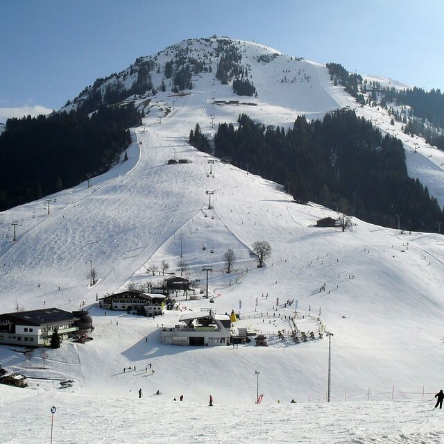
The Ski Welt is one of the biggest and best ski areas in Austria. The lift system is efficient and modern. It is really an intermediates paradise. There are a number of black runs and reasonable off-piste for experts. Those new to the sport have many blues to explore but limited facilities for beginners in the village of Söll itself and the home mountain (Hohe Salve) has a long blue into town, but otherwise more for experienced skiers. Mountain restaurants in the whole area are excellent and plentiful. Söll itself used to be quite a lively resort in the evenings but in the last 3 or 4 years has quietened down a lot to the extent nightlife is almost non existent apart from a few bars, a couple with live music some days. The resort made a decision to focus on families.
Stephen Henry da United Kingdom scrive:
The Ski Welt is one of the biggest and best ski areas in Austria. The lift system is efficient and modern. It is really an intermediates paradise. There are a number of black runs and reasonable off-piste for experts. Those new to the sport have many blues to explore but limited facilities for beginners in the village of Söll itself and the home mountain (Hohe Salve) has a long blue into town, but otherwise more for experienced skiers. Mountain restaurants in the whole area are excellent and plentiful. Söll itself used to be quite a lively resort in the evenings but in the last 3 or 4 years has quietened down a lot to the extent nightlife is almost non existent apart from a few bars, a couple with live music some days. The resort made a decision to focus on families.


 Nearest