Ultimi 6 giorniScorri a sinistra per gli ultimi 6 giorniOra
Next 4 days weather summary:
Pioggia moderata (totale 18.0mm), più pesante Domenica pomeriggio. Caldo (max 25°C Sabato pomeriggio, min 8°C Giovedì notte). Vento sarà generalmente leggero.
Giorni 5-7 Saalbach Hinterglemm sommario meteo
Pioggia leggera (totale 9.0mm), per lo più che cade Domenica notte. Caldo (max 29°C Mercoledì pomeriggio, min 12°C Domenica notte). Vento sarà generalmente leggero.
La tabella sopra da le previsioni meteo per Saalbach Hinterglemm a specifiche altezze 1003 m. I nostri sofisticati modelli meteo ci consentono di fornire previsioni neve per la vetta, l'area intermedia e a valle delle stazioni sciistiche di Saalbach Hinterglemm. Per accedere alle previsioni meteo ad altre altezze, per spostarti usa tab sopra la tabella. Per una visione meteo piu' ampia , controlla la mappa meteo di Austria.
Clicca qui per leggere ulteriori informazioni sullo zero termico e il nostro sistema di prevedere le temperature.
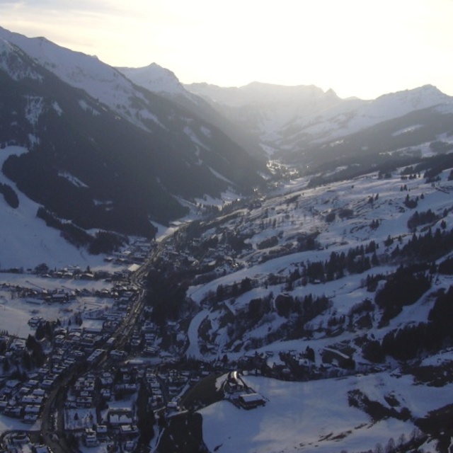
Recensioni dei visitatori di Saalbach Hinterglemm
Complessivamente 4.3 Basato su 38 voti e 47 recensioni
Just come back from a lovely time in Saalbach Hinterglemm. The people are very friendly and welcoming, lots of fun apres-ski, good skiing and lots of things for the non-skiers too.
Whilst we were there they had unprecedented amounts of snow to deal with. Everyone was making a tremendous effort to keep the roads clear and the pistes and resort safe. Quite a few of the links and runs were not open as a result. However, there was still plenty of fun to be had.
We normally go to France and felt that the lifts, general customer service / friendliness and prices for food and provisions were all much better. There's loads of really lovely places to eat in Hinterglemm and on the mountain which won't break the bank.
We had a non-skier with us and there was plenty to do. Lots of lovely walks, easy to get into Zell Am See to visit the pool or watch the ice hockey. The tree top walk at the Lengau is well worth a visit. ice skating, bowling, tobogganing. Plenty to keep busy.
On the downside, the links between lifts and runs at resort level were often complex and required quite a bit of walking and navigating your way around. I'd also say that this isn't the best resort for beginners, so wouldn't pick it if you and your family were having your first skiing holiday.
All in all, we really enjoyed the Austrian hospitality and would definitely visit again.
Complessivamente: 4.3 Basato su 38 voti e 47 recensioni
Snowsure
4.0
Varietà di piste
4.4
Fuoripista
3.6
Paesaggio
4.5
Apres-Ski
4.9
Louise R da United Kingdom scrive:
Just come back from a lovely time in Saalbach Hinterglemm. The people are very friendly and welcoming, lots of fun apres-ski, good skiing and lots of things for the non-skiers too.
Whilst we were there they had unprecedented amounts of snow to deal with. Everyone was making a tremendous effort to keep the roads clear and the pistes and resort safe. Quite a few of the links and runs were not open as a result. However, there was still plenty of fun to be had.
We normally go to France and felt that the lifts, general customer service / friendliness and prices for food and provisions were all much better. There's loads of really lovely places to eat in Hinterglemm and on the mountain which won't break the bank.
We had a non-skier with us and there was plenty to do. Lots of lovely walks, easy to get into Zell Am See to visit the pool or watch the ice hockey. The tree top walk at the Lengau is well worth a visit. ice skating, bowling, tobogganing. Plenty to keep busy.
On the downside, the links between lifts and runs at resort level were often complex and required quite a bit of walking and navigating your way around. I'd also say that this isn't the best resort for beginners, so wouldn't pick it if you and your family were having your first skiing holiday.
All in all, we really enjoyed the Austrian hospitality and would definitely visit again.
Gratis Snow-Forecast.com weather widget per il tho sito
Il Saalbach Hinterglemm widget meteo qui sotto è disponibile per essere incorporato su siti Web esterni a titolo gratuito. Esso fornisce un riepilogo giornaliero delle nostre Saalbach Hinterglemm previsioni meteo neve e dati meteo. Basta andare alla pagina di configurazione e seguire 3 semplici passi per prendere il codice html personalizzato ed incollarlo nel tuo sito. È possibile scegliere l'elevazione di previsione di neve (vetta, metà o piede della montagna) e l'unità metrica/imperiale per le previsioni meteo neve adeguata al proprio sito Web Clicca qui per ottenere il codice


 Nearest