

America’s Next Indoor Snow Centre Takes Shape
Construction of a new indoor snow centre for skiers, boarders and tubers appears to be making good progress at Heritage Farm in Wayne County, West Virginia.

Next 3 days weather summary:Pioggia moderata (totale 11.0mm), più pesante Martedì pomeriggio. Temperature moderate (max 15°C Lunedì pomeriggio, min 9°C Martedì notte). Vento sarà generalmente leggero. | Giorni 4-6 Montafon sommario meteoPioggia abbondante (totale 31.0mm), più pesante durante Sabato notte. Caldo (max 21°C Sabato pomeriggio, min 9°C Giovedì notte). Vento sarà generalmente leggero. | |||||||||||||||||
Lunedì 20 | Martedì 21 | Mercoledì 22 | Giovedì 23 | Venerdì 24 | Sabato 25 | |||||||||||||
AM | PM | notte | AM | PM | notte | AM | PM | notte | AM | PM | notte | AM | PM | notte | AM | PM | notte | |
rischio temporale | rischio temporale | rovesci pioggia | rischio temporale | rovesci pioggia | rovesci pioggia | limpido | limpido | poche nuvole | rovesci pioggia | rovesci pioggia | rovesci pioggia | limpido | poche nuvole | limpido | limpido | poche nuvole | forte pioggia | |
km/h | ||||||||||||||||||
Mappa neve |  |  |  |  |  |  | ||||||||||||
— | — | — | — | — | — | — | — | — | — | — | — | — | — | — | — | — | — | |
mm | 1 | 2 | 2 | 2 | 3 | 1 | — | — | — | 1 | 3 | 2 | — | — | — | — | — | 25 |
max °C | 14 | 15 | 13 | 13 | 14 | 12 | 12 | 15 | 13 | 11 | 11 | 11 | 14 | 17 | 14 | 17 | 21 | 16 |
min °C | 11 | 14 | 11 | 11 | 13 | 9 | 10 | 15 | 10 | 10 | 11 | 9 | 10 | 17 | 12 | 14 | 20 | 9 |
chill °C | 11 | 14 | 11 | 11 | 12 | 9 | 10 | 15 | 10 | 10 | 10 | 9 | 10 | 17 | 12 | 14 | 20 | 9 |
Umido. % | 69 | 68 | 76 | 74 | 55 | 67 | 56 | 45 | 62 | 72 | 65 | 65 | 32 | 34 | 53 | 40 | 36 | 98 |
Zero termico m | 3500 | 3600 | 3650 | 3450 | 3250 | 2950 | 3200 | 3450 | 3150 | 3000 | 3000 | 3000 | 3900 | 3900 | 3950 | 3950 | 4200 | 3500 |
5:43 | — | — | 5:45 | — | — | 5:46 | — | — | 5:48 | — | — | 5:48 | — | — | 5:50 | — | — | |
— | — | 9:07 | — | — | 9:06 | — | — | 9:05 | — | — | 9:04 | — | — | 9:02 | — | — | 9:01 | |
Diventa pro e intaglia:
Informazioni valanghe: European Avalanche Warning Services (EAWS)
Gli ultimi report della neve vicino a Montafon:
| La profondità maggiore della neve é: | 0 cm |
|---|---|
| La profondità minore della neve é: | 0 cm |
| Fresh snowfall depth: | — |
| Quando ha nevicato l'ultima volta? | 16 May 2026 |
0.0 | Giorni neve fresca Neve fresca, prevalentemente soleggiato, vento debole. |
|---|---|
0.0 | Giorni neve fresca Fresh snow, limited sun, any wind. |
0.0 | Giorni Bluebird Neve media, prevalentemente soleggiato, vento debole. |
La tabella sopra da le previsioni meteo per Montafon a specifiche altezze 1650 m. I nostri sofisticati modelli meteo ci consentono di fornire previsioni neve per la vetta, l'area intermedia e a valle delle stazioni sciistiche di Montafon. Per accedere alle previsioni meteo ad altre altezze, per spostarti usa tab sopra la tabella. Per una visione meteo piu' ampia , controlla la mappa meteo di Austria.
Clicca qui per leggere ulteriori informazioni sullo zero termico e il nostro sistema di prevedere le temperature.
Complessivamente 4.1 Basato su 20 voti e 3 recensioni
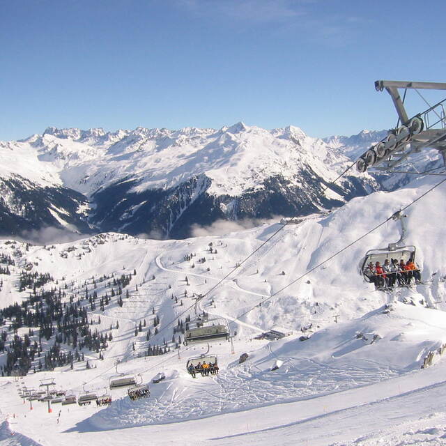
Montafon is an excellent destination in Vorarlberg. Access by car is assured also during heavy snow fall and you can choose between different parking areas in Schruns, St. Gallenkirch or Gaschurn. Offer of perfectly groomed slopes goes from easy ones in Kapell area to black ones. This season, with a lot of snow, the Black Scorpion in the back of Versettla was fantastic. But, in general, all very large slopes. Guaranteed good rides also on weekends when it is crowded. I suggest, also, the Hochjochtotal from 2400m down to 700m in Schruns or from Sennigrat to Silbertal. Restaurants and bars are available everywhere and with the sun shining nothing's better than to chill out on the terrace. A good tip is to ski during weekdays, to avoid crowded slopes and traffic jams early in the morning and later in the afternoon.
Massimo Anselmi da Italy scrive:
Montafon is an excellent destination in Vorarlberg. Access by car is assured also during heavy snow fall and you can choose between different parking areas in Schruns, St. Gallenkirch or Gaschurn.
Offer of perfectly groomed slopes goes from easy ones in Kapell area to black ones. This season, with a lot of snow, the Black Scorpion in the back of Versettla was fantastic. But, in general, all very large slopes. Guaranteed good rides also on weekends when it is crowded.
I suggest, also, the Hochjochtotal from 2400m down to 700m in Schruns or from Sennigrat to Silbertal.
Restaurants and bars are available everywhere and with the sun shining nothing's better than to chill out on the terrace.
A good tip is to ski during weekdays, to avoid crowded slopes and traffic jams early in the morning and later in the afternoon.


 Nearest