

Portillo Re-Opens To Guests Arriving By Helicopter
Chile’s famous Portillo ski resort is reported to have re-opened to guests arriving by helicopter after being cut off by road for more than two weeks by over 6m/20 feet of snowfall.

Next 3 days weather summary:Pioggia abbondante (totale 30.0mm), più pesante durante Mercoledì notte. Temperature moderate (max 17°C Lunedì pomeriggio, min 12°C Martedì notte). Vento sarà generalmente leggero. | Giorni 4-6 Kühtai sommario meteoPioggia abbondante (totale 33.0mm), più pesante durante Giovedì pomeriggio. Temperature moderate (max 14°C Giovedì pomeriggio, min 9°C Giovedì notte). Vento sarà generalmente leggero. | ||||||||||||||||
Lun 3 | Martedì 4 | Mercoledì 5 | Giovedì 6 | Venerdì 7 | Sabato 8 | ||||||||||||
PM | notte | AM | PM | notte | AM | PM | notte | AM | PM | notte | AM | PM | notte | AM | PM | notte | |
rovesci pioggia | poche nuvole | limpido | rischio temporale | rovesci pioggia | rischio temporale | rischio temporale | rovesci pioggia | rischio temporale | rischio temporale | forte pioggia | rischio temporale | rischio temporale | rovesci pioggia | poche nuvole | rischio temporale | rovesci pioggia | |
km/h | |||||||||||||||||
Mappa neve |  |  |  |  |  |  | |||||||||||
— | — | — | — | — | — | — | — | — | — | — | — | — | — | — | — | — | |
mm | 2 | — | — | 3 | 1 | 1 | 5 | 13 | 5 | 10 | 14 | 2 | 3 | 1 | — | 2 | 1 |
max °C | 17 | 16 | 17 | 17 | 15 | 15 | 16 | 14 | 14 | 14 | 11 | 10 | 12 | 11 | 12 | 13 | 11 |
min °C | 14 | 13 | 14 | 15 | 12 | 13 | 16 | 12 | 13 | 14 | 9 | 9 | 11 | 9 | 10 | 12 | 11 |
chill °C | 14 | 12 | 14 | 15 | 12 | 13 | 16 | 12 | 13 | 14 | 8 | 9 | 11 | 9 | 10 | 12 | 11 |
Umido. % | 66 | 66 | 51 | 68 | 70 | 68 | 71 | 87 | 72 | 75 | 98 | 85 | 85 | 87 | 76 | 80 | 61 |
Zero termico m | 4500 | 4500 | 4500 | 4600 | 4500 | 4400 | 4550 | 4400 | 4350 | 4350 | 3950 | 3950 | 4000 | 4100 | 4000 | 4150 | 4350 |
— | — | 5:56 | — | — | 5:58 | — | — | 6:00 | — | — | 6:01 | — | — | 6:01 | — | — | |
— | 8:46 | — | — | 8:45 | — | — | 8:44 | — | — | 8:42 | — | — | 8:40 | — | — | 8:38 | |
Diventa pro e intaglia:
Informazioni valanghe: European Avalanche Warning Services (EAWS)
Gli ultimi report della neve vicino a Kühtai:
| La profondità maggiore della neve é: | 0 cm |
|---|---|
| La profondità minore della neve é: | 0 cm |
| Fresh snowfall depth: | — |
| Quando ha nevicato l'ultima volta? | 10 Jun 2026 |
0.0 | Giorni neve fresca Neve fresca, prevalentemente soleggiato, vento debole. |
|---|---|
0.0 | Giorni neve fresca Fresh snow, limited sun, any wind. |
0.0 | Giorni Bluebird Neve media, prevalentemente soleggiato, vento debole. |
La tabella sopra da le previsioni meteo per Kühtai a specifiche altezze 2270 m. I nostri sofisticati modelli meteo ci consentono di fornire previsioni neve per la vetta, l'area intermedia e a valle delle stazioni sciistiche di Kühtai. Per accedere alle previsioni meteo ad altre altezze, per spostarti usa tab sopra la tabella. Per una visione meteo piu' ampia , controlla la mappa meteo di Austria.
Clicca qui per leggere ulteriori informazioni sullo zero termico e il nostro sistema di prevedere le temperature.
Il nome della localita' è scritto anche come Kuehtai.
Complessivamente 4.1 Basato su 23 voti e 7 recensioni
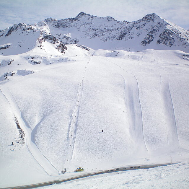
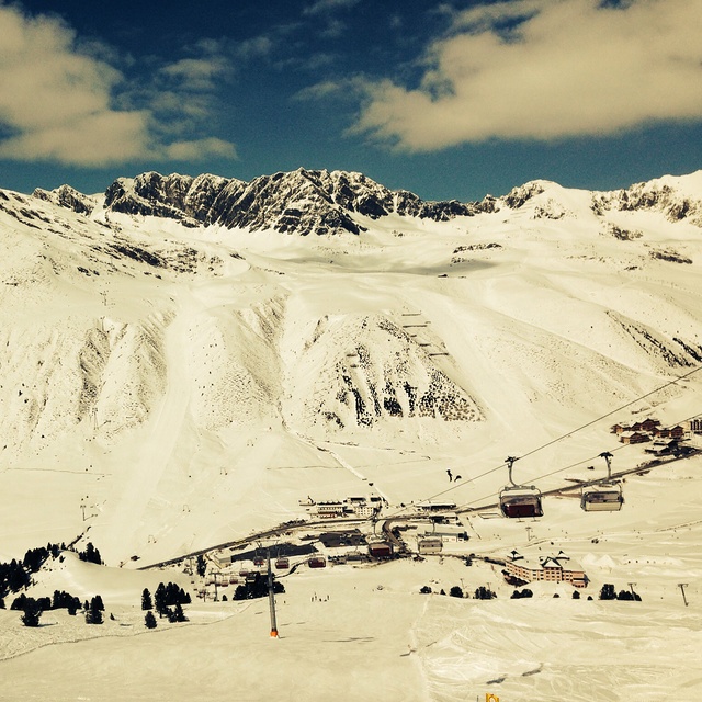
A long overdue review on Kuhtai, which 've skied may times in the past few years. In short, another classic medium size resort with approx 40 km of pistes which the Austrians do so well. With a base station of 2,000m it's super snow-sure if rather bleak as it's a one street station at the top of a pass, all above the tree line. Make no mistake though, this is a serious ski resort, sporting a modern lift system with all the pistes being either red or black, save one blue run that finishes at the top of a long red canyon; so it's not a resort for beginners! Its serious sporting intent is underlined by the fact the the US World Cup Ski Team is based here when the World Cup is in Europe. The slopes face both north and south so you can follow the sun each day, plus there are plenty of off-piste and back-country opportunities. Subsistence is good value compared to the big resorts like Soelden, Ischgl and St Anton. But best of all is the fact the pistes are generally deserted on mid week days and there are very few Brits around, so you really feel you are on a foreign holiday. Overall, highly recommended for long weekend or away days in neighbouring resorts. It's also worth noting the lift pass is shared with nearby Oetz, another similar sized gem.
Tirolerhund da United Kingdom scrive:
A long overdue review on Kuhtai, which 've skied may times in the past few years. In short, another classic medium size resort with approx 40 km of pistes which the Austrians do so well.
With a base station of 2,000m it's super snow-sure if rather bleak as it's a one street station at the top of a pass, all above the tree line.
Make no mistake though, this is a serious ski resort, sporting a modern lift system with all the pistes being either red or black, save one blue run that finishes at the top of a long red canyon; so it's not a resort for beginners!
Its serious sporting intent is underlined by the fact the the US World Cup Ski Team is based here when the World Cup is in Europe.
The slopes face both north and south so you can follow the sun each day, plus there are plenty of off-piste and back-country opportunities.
Subsistence is good value compared to the big resorts like Soelden, Ischgl and St Anton. But best of all is the fact the pistes are generally deserted on mid week days and there are very few Brits around, so you really feel you are on a foreign holiday.
Overall, highly recommended for long weekend or away days in neighbouring resorts. It's also worth noting the lift pass is shared with nearby Oetz, another similar sized gem.


 Nearest