

America’s Next Indoor Snow Centre Takes Shape
Construction of a new indoor snow centre for skiers, boarders and tubers appears to be making good progress at Heritage Farm in Wayne County, West Virginia.

Next 3 days weather summary:Pioggia leggera (totale 6.0mm), per lo più che cade Martedì mattina. Temperature moderate (max 16°C Mercoledì pomeriggio, min 9°C Martedì notte). Vento sarà generalmente leggero. | Giorni 4-6 Courmayeur sommario meteoPioggia abbondante (totale 33.0mm), più pesante durante Sabato notte. Caldo (max 20°C Sabato pomeriggio, min 8°C Domenica notte). Vento sarà generalmente leggero. | |||||||||||||||||
Martedì 21 | Mercoledì 22 | Giovedì 23 | Venerdì 24 | Sabato 25 | Domenica 26 | |||||||||||||
AM | PM | notte | AM | PM | notte | AM | PM | notte | AM | PM | notte | AM | PM | notte | AM | PM | notte | |
rischio temporale | rischio temporale | limpido | limpido | limpido | limpido | poche nuvole | limpido | limpido | limpido | limpido | limpido | poche nuvole | poche nuvole | forte pioggia | rovesci pioggia | pioggia leggera | pioggia leggera | |
km/h | ||||||||||||||||||
Mappa neve |  |  |  |  |  |  | ||||||||||||
— | — | — | — | — | — | — | — | — | — | — | — | — | — | — | — | — | — | |
mm | 4 | 2 | — | — | — | — | — | — | — | — | — | — | — | — | 23 | 1 | 4 | 5 |
max °C | 14 | 15 | 12 | 13 | 16 | 14 | 13 | 14 | 12 | 15 | 17 | 16 | 18 | 20 | 12 | 12 | 12 | 10 |
min °C | 12 | 14 | 9 | 10 | 16 | 9 | 11 | 14 | 9 | 11 | 17 | 12 | 13 | 19 | 9 | 10 | 11 | 8 |
chill °C | 11 | 13 | 9 | 10 | 16 | 8 | 10 | 14 | 9 | 11 | 17 | 12 | 13 | 19 | 9 | 10 | 10 | 7 |
Umido. % | 54 | 49 | 60 | 34 | 44 | 44 | 43 | 45 | 56 | 24 | 34 | 38 | 35 | 46 | 95 | 67 | 74 | 96 |
Zero termico m | 3700 | 3700 | 3700 | 3850 | 4000 | 3900 | 3600 | 3750 | 3900 | 4150 | 4300 | 4350 | 4300 | 4350 | 3550 | 3550 | 3550 | 3350 |
6:01 | — | — | 6:03 | — | — | 6:03 | — | — | 6:05 | — | — | 6:05 | — | — | 6:07 | — | — | |
— | — | 9:14 | — | — | 9:13 | — | — | 9:12 | — | — | 9:10 | — | — | 9:09 | — | — | 9:08 | |
Diventa pro e intaglia:
Informazioni valanghe: European Avalanche Warning Services (EAWS)
Gli ultimi report della neve vicino a Courmayeur:
| La profondità maggiore della neve é: | 0 cm |
|---|---|
| La profondità minore della neve é: | 0 cm |
| Fresh snowfall depth: | — |
| Quando ha nevicato l'ultima volta? | 16 May 2026 |
0.0 | Giorni neve fresca Neve fresca, prevalentemente soleggiato, vento debole. |
|---|---|
0.0 | Giorni neve fresca Fresh snow, limited sun, any wind. |
0.0 | Giorni Bluebird Neve media, prevalentemente soleggiato, vento debole. |

La tabella sopra da le previsioni meteo per Courmayeur a specifiche altezze 1982 m. I nostri sofisticati modelli meteo ci consentono di fornire previsioni neve per la vetta, l'area intermedia e a valle delle stazioni sciistiche di Courmayeur. Per accedere alle previsioni meteo ad altre altezze, per spostarti usa tab sopra la tabella. Per una visione meteo piu' ampia , controlla la mappa meteo di Italy.
Clicca qui per leggere ulteriori informazioni sullo zero termico e il nostro sistema di prevedere le temperature.
Complessivamente 4.0 Basato su 28 voti e 22 recensioni
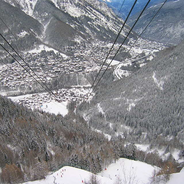
Was in Courmayeur in Jan 2019. Have to agree with much of what another reviewer said. Good skiing for beginners and intermediates. We had fabulous weather and it was great to sit outside and enjoy a daytime beer or eat half way up/down the mountain. Lovely but small town, some nice restaurants and a few good bars but generally the town is very quiet. If you want a buzzing night life, Courmayeur is not for you. BTW - you must take half a day off skiing to take the Skyway (lift) which is a short bus ride from Courmayeur town to Punta Helbronner, 3466m up Monte Blanc. Fabulous views going up and from the viewing platform at the top.
Rick da United Kingdom scrive:
Was in Courmayeur in Jan 2019. Have to agree with much of what another reviewer said.
Good skiing for beginners and intermediates. We had fabulous weather and it was great to sit outside and enjoy a daytime beer or eat half way up/down the mountain.
Lovely but small town, some nice restaurants and a few good bars but generally the town is very quiet. If you want a buzzing night life, Courmayeur is not for you.
BTW - you must take half a day off skiing to take the Skyway (lift) which is a short bus ride from Courmayeur town to Punta Helbronner, 3466m up Monte Blanc. Fabulous views going up and from the viewing platform at the top.


 Nearest