

America’s Next Indoor Snow Centre Takes Shape
Construction of a new indoor snow centre for skiers, boarders and tubers appears to be making good progress at Heritage Farm in Wayne County, West Virginia.

Next 3 days weather summary:Pioggia leggera (totale 8.0mm), per lo più che cade Martedì mattina. Temperature moderate (max 19°C Mercoledì pomeriggio, min 7°C Martedì notte). Vento sarà generalmente leggero. | Giorni 4-6 Chandolin sommario meteoPioggia abbondante (totale 45.0mm), più pesante durante Sabato notte. Caldo (max 23°C Sabato pomeriggio, min 9°C Domenica notte). Vento sarà generalmente leggero. | |||||||||||||||||
Martedì 21 | Mercoledì 22 | Giovedì 23 | Venerdì 24 | Sabato 25 | Domenica 26 | |||||||||||||
AM | PM | notte | AM | PM | notte | AM | PM | notte | AM | PM | notte | AM | PM | notte | AM | PM | notte | |
rischio temporale | rischio temporale | rovesci pioggia | limpido | limpido | limpido | poche nuvole | poche nuvole | limpido | limpido | limpido | limpido | poche nuvole | rischio temporale | forte pioggia | rischio temporale | pioggia leggera | pioggia moderata | |
km/h | ||||||||||||||||||
Mappa neve |  |  |  |  |  |  | ||||||||||||
— | — | — | — | — | — | — | — | — | — | — | — | — | — | — | — | — | — | |
mm | 4 | 3 | 1 | — | — | — | — | — | — | — | — | — | — | 1 | 27 | 5 | 5 | 7 |
max °C | 15 | 17 | 13 | 15 | 19 | 15 | 15 | 18 | 14 | 16 | 20 | 16 | 20 | 23 | 15 | 14 | 14 | 11 |
min °C | 11 | 16 | 7 | 10 | 18 | 7 | 11 | 17 | 7 | 11 | 19 | 10 | 14 | 19 | 10 | 11 | 13 | 9 |
chill °C | 11 | 16 | 7 | 10 | 18 | 7 | 11 | 17 | 7 | 11 | 19 | 10 | 14 | 19 | 10 | 11 | 12 | 9 |
Umido. % | 65 | 55 | 78 | 41 | 36 | 60 | 44 | 39 | 68 | 30 | 28 | 60 | 33 | 52 | 96 | 70 | 70 | 95 |
Zero termico m | 3650 | 3550 | 3550 | 3850 | 3900 | 3800 | 3600 | 3600 | 3800 | 4150 | 4200 | 4300 | 4350 | 4250 | 3500 | 3600 | 3600 | 3350 |
5:58 | — | — | 5:58 | — | — | 6:00 | — | — | 6:01 | — | — | 6:01 | — | — | 6:03 | — | — | |
— | — | 9:13 | — | — | 9:12 | — | — | 9:10 | — | — | 9:09 | — | — | 9:08 | — | — | 9:07 | |
Diventa pro e intaglia:
Informazioni valanghe: European Avalanche Warning Services (EAWS)
Gli ultimi report della neve vicino a Chandolin:
| La profondità maggiore della neve é: | 0 cm |
|---|---|
| La profondità minore della neve é: | 0 cm |
| Fresh snowfall depth: | — |
| Quando ha nevicato l'ultima volta? | 10 Jun 2026 |
0.0 | Giorni neve fresca Neve fresca, prevalentemente soleggiato, vento debole. |
|---|---|
0.0 | Giorni neve fresca Fresh snow, limited sun, any wind. |
0.0 | Giorni Bluebird Neve media, prevalentemente soleggiato, vento debole. |


La tabella sopra da le previsioni meteo per Chandolin a specifiche altezze 1650 m. I nostri sofisticati modelli meteo ci consentono di fornire previsioni neve per la vetta, l'area intermedia e a valle delle stazioni sciistiche di Chandolin. Per accedere alle previsioni meteo ad altre altezze, per spostarti usa tab sopra la tabella. Per una visione meteo piu' ampia , controlla la mappa meteo di Switzerland.
Clicca qui per leggere ulteriori informazioni sullo zero termico e il nostro sistema di prevedere le temperature.
Complessivamente 3.8 Basato su 14 voti e 3 recensioni
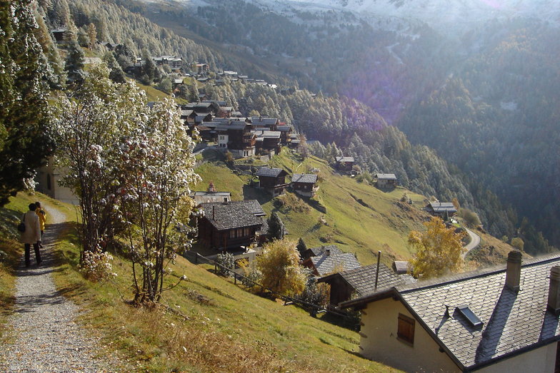
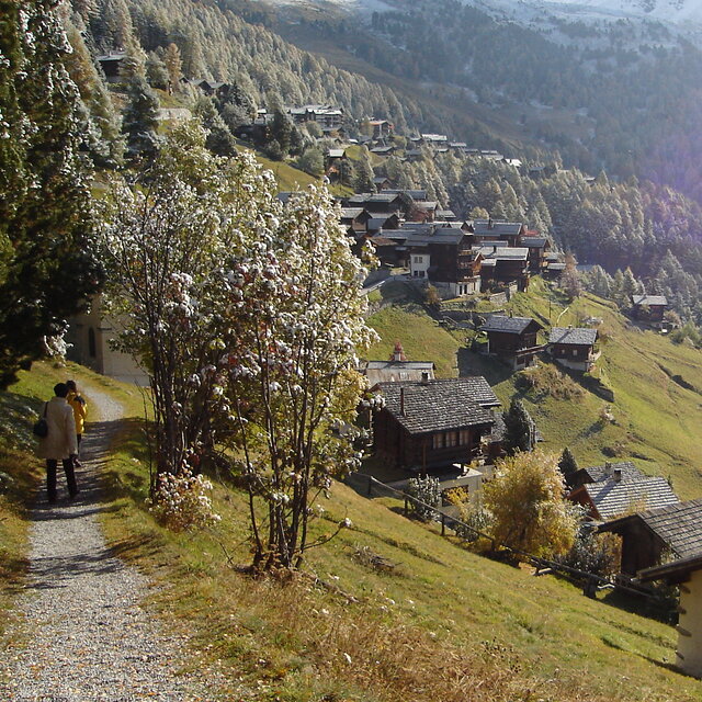
Chandolin is a sleepy little village located high on a sunny bench, precariously perched above the Val d'Anniviers. The ski area is shared with St. Luc, a bigger village with better lift access a few k's back along the road. Since Chandolin is arguably the highest village in Switzerland the road can be very slippery, especially after sunny afternoons have allowed a bit of runoff. The resort is tiny, nightlife non-existent and the lifts are antiquated yet it is still one of my favorite places in Switzerland. The combined ski area is respectably big, invariably quiet, sunny, and after new snow, the off-pitse is excellent. Lack of crowds mean that it can stay that way for several days, especially through the trees. Views are spectacular and lift tickets reasonably affordable. The old part of the village is especially picturesque. All in all it is an excellent place from which to explore the diverse and largely undiscovered slopes of the Anniviers Valley. It is helpful to have your own transport if that's your plan.
Rob da United Kingdom scrive:
Chandolin is a sleepy little village located high on a sunny bench, precariously perched above the Val d'Anniviers. The ski area is shared with St. Luc, a bigger village with better lift access a few k's back along the road. Since Chandolin is arguably the highest village in Switzerland the road can be very slippery, especially after sunny afternoons have allowed a bit of runoff.
The resort is tiny, nightlife non-existent and the lifts are antiquated yet it is still one of my favorite places in Switzerland. The combined ski area is respectably big, invariably quiet, sunny, and after new snow, the off-pitse is excellent. Lack of crowds mean that it can stay that way for several days, especially through the trees. Views are spectacular and lift tickets reasonably affordable. The old part of the village is especially picturesque. All in all it is an excellent place from which to explore the diverse and largely undiscovered slopes of the Anniviers Valley. It is helpful to have your own transport if that's your plan.


 Nearest