

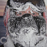
Portillo Re-Opens To Guests Arriving By Helicopter
Chile’s famous Portillo ski resort is reported to have re-opened to guests arriving by helicopter after being cut off by road for more than two weeks by over 6m/20 feet of snowfall.

Next 3 days weather summary:Pioggia abbondante (totale 30.0mm), più pesante durante Mercoledì notte. Caldo (max 23°C Mercoledì pomeriggio, min 14°C Lunedì notte). Vento sarà generalmente leggero. | Giorni 4-6 Champoluc sommario meteoPioggia abbondante (totale 32.0mm), più pesante durante Giovedì notte. Caldo (max 23°C Giovedì pomeriggio, min 12°C Giovedì notte). Vento sarà generalmente leggero. | ||||||||||||||||
Lun 3 | Martedì 4 | Mercoledì 5 | Giovedì 6 | Venerdì 7 | Sabato 8 | ||||||||||||
PM | notte | AM | PM | notte | AM | PM | notte | AM | PM | notte | AM | PM | notte | AM | PM | notte | |
rischio temporale | rovesci pioggia | limpido | rischio temporale | rovesci pioggia | limpido | rischio temporale | rovesci pioggia | limpido | rischio temporale | rovesci pioggia | rischio temporale | rischio temporale | rovesci pioggia | rovesci pioggia | rischio temporale | rovesci pioggia | |
km/h | |||||||||||||||||
Mappa neve |  |  |  |  |  |  | |||||||||||
— | — | — | — | — | — | — | — | — | — | — | — | — | — | — | — | — | |
mm | 6 | 5 | — | 3 | 6 | — | 3 | 7 | — | 4 | 13 | 1 | 3 | 2 | 1 | 3 | 4 |
max °C | 20 | 18 | 21 | 22 | 18 | 21 | 23 | 18 | 22 | 23 | 15 | 20 | 22 | 18 | 20 | 21 | 18 |
min °C | 20 | 14 | 16 | 22 | 14 | 17 | 22 | 14 | 17 | 18 | 12 | 15 | 21 | 13 | 15 | 21 | 13 |
chill °C | 20 | 14 | 16 | 22 | 14 | 17 | 22 | 14 | 17 | 18 | 12 | 15 | 21 | 13 | 15 | 21 | 13 |
Umido. % | 65 | 69 | 53 | 53 | 66 | 46 | 52 | 66 | 49 | 78 | 84 | 54 | 54 | 75 | 60 | 58 | 79 |
Zero termico m | 4450 | 4400 | 4350 | 4400 | 4500 | 4450 | 4550 | 4450 | 4400 | 4400 | 4300 | 4200 | 4400 | 4250 | 4300 | 4400 | 4300 |
— | — | 6:13 | — | — | 6:15 | — | — | 6:16 | — | — | 6:18 | — | — | 6:18 | — | — | |
— | 8:55 | — | — | 8:53 | — | — | 8:52 | — | — | 8:52 | — | — | 8:50 | — | — | 8:49 | |
Diventa pro e intaglia:
Informazioni valanghe: European Avalanche Warning Services (EAWS)
Gli ultimi report della neve vicino a Champoluc:
| La profondità maggiore della neve é: | — |
|---|---|
| La profondità minore della neve é: | — |
| Fresh snowfall depth: | — |
| Quando ha nevicato l'ultima volta? | 18 May 2026 |
0.0 | Giorni neve fresca Neve fresca, prevalentemente soleggiato, vento debole. |
|---|---|
0.0 | Giorni neve fresca Fresh snow, limited sun, any wind. |
0.0 | Giorni Bluebird Neve media, prevalentemente soleggiato, vento debole. |
La tabella sopra da le previsioni meteo per Champoluc a specifiche altezze 1587 m. I nostri sofisticati modelli meteo ci consentono di fornire previsioni neve per la vetta, l'area intermedia e a valle delle stazioni sciistiche di Champoluc. Per accedere alle previsioni meteo ad altre altezze, per spostarti usa tab sopra la tabella. Per una visione meteo piu' ampia , controlla la mappa meteo di Italy.
Clicca qui per leggere ulteriori informazioni sullo zero termico e il nostro sistema di prevedere le temperature.
Complessivamente 4.2 Basato su 24 voti e 23 recensioni
Just back from this hidden treasure of a resort. Wonderful variety of slopes with superb views. Dead quiet with no lines for ski pass, lifts, restaurants etc. Many cosy restaurants on the slopes and very well priced. Stayed at the Le Rocher hotel: spotless, great food and comfortable. Also access to a super spa 5 minutes away. This place is largely unknown. Go, you will not be disappointed. It's truly unspoilt and brilliant fun (way better than those faceless French resorts).
walt da South Africa scrive:
Just back from this hidden treasure of a resort. Wonderful variety of slopes with superb views. Dead quiet with no lines for ski pass, lifts, restaurants etc. Many cosy restaurants on the slopes and very well priced. Stayed at the Le Rocher hotel: spotless, great food and comfortable. Also access to a super spa 5 minutes away.
This place is largely unknown. Go, you will not be disappointed. It's truly unspoilt and brilliant fun (way better than those faceless French resorts).


 Nearest