

Portillo Re-Opens To Guests Arriving By Helicopter
Chile’s famous Portillo ski resort is reported to have re-opened to guests arriving by helicopter after being cut off by road for more than two weeks by over 6m/20 feet of snowfall.

Next 3 days weather summary:Pioggia abbondante (totale 46.0mm), più pesante durante Lunedì notte. Temperature moderate (max 18°C Lunedì pomeriggio, min 12°C Martedì pomeriggio). Vento sarà generalmente leggero. | Giorni 4-6 Champéry sommario meteoPioggia moderata (totale 10.0mm), più pesante Giovedì pomeriggio. Temperature moderate (max 14°C Giovedì mattina, min 10°C Giovedì notte). Vento sarà generalmente leggero. | |||||||||||||||||
Lunedì 3 | Martedì 4 | Mercoledì 5 | Giovedì 6 | Venerdì 7 | Sabato 8 | |||||||||||||
AM | PM | notte | AM | PM | notte | AM | PM | notte | AM | PM | notte | AM | PM | notte | AM | PM | notte | |
limpido | rischio temporale | rovesci pioggia | limpido | rischio temporale | rovesci pioggia | limpido | rovesci pioggia | rovesci pioggia | limpido | pioggia moderata | rovesci pioggia | limpido | poche nuvole | limpido | limpido | limpido | limpido | |
km/h | ||||||||||||||||||
Mappa neve |  |  |  |  |  |  | ||||||||||||
— | — | — | — | — | — | — | — | — | — | — | — | — | — | — | — | — | — | |
mm | — | 4 | 17 | — | 13 | 10 | — | 1 | 1 | — | 8 | 2 | — | — | — | — | — | — |
max °C | 17 | 18 | 14 | 15 | 16 | 13 | 14 | 15 | 15 | 14 | 12 | 10 | 11 | 12 | 12 | 13 | 14 | 14 |
min °C | 15 | 14 | 14 | 14 | 12 | 12 | 13 | 15 | 13 | 13 | 11 | 10 | 10 | 12 | 11 | 11 | 14 | 13 |
chill °C | 15 | 13 | 14 | 14 | 12 | 12 | 13 | 15 | 13 | 13 | 10 | 10 | 10 | 12 | 11 | 11 | 14 | 12 |
Umido. % | 44 | 78 | 65 | 58 | 87 | 66 | 62 | 66 | 60 | 60 | 87 | 80 | 68 | 59 | 46 | 37 | 44 | 44 |
Zero termico m | 4550 | 4400 | 4500 | 4500 | 4350 | 4400 | 4300 | 4350 | 4400 | 4300 | 4300 | 4150 | 4150 | 4250 | 4350 | 4300 | 4200 | 4250 |
6:16 | — | — | 6:16 | — | — | 6:18 | — | — | 6:18 | — | — | 6:20 | — | — | 6:22 | — | — | |
— | — | 9:00 | — | — | 8:59 | — | — | 8:58 | — | — | 8:55 | — | — | 8:54 | — | — | 8:53 | |
Diventa pro e intaglia:
Informazioni valanghe: European Avalanche Warning Services (EAWS)
Gli ultimi report della neve vicino a Champéry:
| La profondità maggiore della neve é: | 122 cm |
|---|---|
| La profondità minore della neve é: | 93 cm |
| Fresh snowfall depth: | — |
| Quando ha nevicato l'ultima volta? | 16 May 2026 |
0.0 | Giorni neve fresca Neve fresca, prevalentemente soleggiato, vento debole. |
|---|---|
0.0 | Giorni neve fresca Fresh snow, limited sun, any wind. |
0.0 | Giorni Bluebird Neve media, prevalentemente soleggiato, vento debole. |

La tabella sopra da le previsioni meteo per Champéry a specifiche altezze 2277 m. I nostri sofisticati modelli meteo ci consentono di fornire previsioni neve per la vetta, l'area intermedia e a valle delle stazioni sciistiche di Champéry. Per accedere alle previsioni meteo ad altre altezze, per spostarti usa tab sopra la tabella. Per una visione meteo piu' ampia , controlla la mappa meteo di Switzerland.
Clicca qui per leggere ulteriori informazioni sullo zero termico e il nostro sistema di prevedere le temperature.
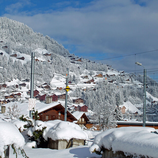
Il nome della localita' è scritto anche come Champery.
Complessivamente 4.1 Basato su 20 voti e 12 recensioni
I stayed in Champery from 23 to 30th December. It was a great holiday in Le Chalet de l'Atelier. But we were disappointed when we rented skis and snowboard in Borgeat Sports. When we weren't agreed on our invoice the man who takes money was very angry and did not explain how he counted our ski and snowboard rent. We don't recommend to use this ski rent company.
Jelena da Switzerland scrive:
I stayed in Champery from 23 to 30th December. It was a great holiday
in Le Chalet de l'Atelier. But we were disappointed when we rented skis and snowboard in Borgeat Sports. When we weren't agreed on our invoice the man who takes money was very angry and did not explain how he counted our ski and snowboard rent. We don't recommend to use this ski rent company.


 Nearest