

America’s Next Indoor Snow Centre Takes Shape
Construction of a new indoor snow centre for skiers, boarders and tubers appears to be making good progress at Heritage Farm in Wayne County, West Virginia.

Next 3 days weather summary:Pioggia leggera (totale 5.0mm), per lo più che cade Martedì mattina. Caldo (max 21°C Mercoledì pomeriggio, min 10°C Martedì notte). Vento sarà generalmente leggero. | Giorni 4-6 Avoriaz sommario meteoPioggia abbondante (totale 26.0mm), più pesante durante Sabato notte. Caldo (max 26°C Sabato pomeriggio, min 10°C Domenica notte). Vento sarà generalmente leggero. | |||||||||||||||||
Martedì 21 | Mercoledì 22 | Giovedì 23 | Venerdì 24 | Sabato 25 | Domenica 26 | |||||||||||||
AM | PM | notte | AM | PM | notte | AM | PM | notte | AM | PM | notte | AM | PM | notte | AM | PM | notte | |
rischio temporale | rovesci pioggia | limpido | limpido | limpido | poche nuvole | poche nuvole | limpido | limpido | limpido | limpido | limpido | poche nuvole | limpido | rovesci pioggia | rischio temporale | pioggia leggera | rovesci pioggia | |
km/h | ||||||||||||||||||
Mappa neve |  |  |  |  |  |  | ||||||||||||
— | — | — | — | — | — | — | — | — | — | — | — | — | — | — | — | — | — | |
mm | 3 | 2 | — | — | — | — | — | — | — | — | — | — | — | — | 13 | 4 | 5 | 4 |
max °C | 18 | 20 | 17 | 18 | 21 | 18 | 18 | 20 | 17 | 19 | 22 | 19 | 24 | 26 | 19 | 18 | 17 | 13 |
min °C | 13 | 20 | 10 | 13 | 20 | 12 | 14 | 20 | 10 | 14 | 22 | 14 | 17 | 25 | 13 | 15 | 16 | 10 |
chill °C | 13 | 20 | 10 | 13 | 20 | 12 | 14 | 20 | 10 | 14 | 22 | 14 | 17 | 25 | 12 | 15 | 16 | 10 |
Umido. % | 67 | 40 | 63 | 47 | 31 | 49 | 47 | 34 | 57 | 40 | 31 | 40 | 29 | 29 | 74 | 61 | 68 | 92 |
Zero termico m | 3600 | 3400 | 3650 | 3950 | 3900 | 3750 | 3600 | 3500 | 4050 | 4250 | 4150 | 4250 | 4100 | 4100 | 3750 | 3550 | 3350 | 3400 |
6:01 | — | — | 6:01 | — | — | 6:03 | — | — | 6:03 | — | — | 6:05 | — | — | 6:05 | — | — | |
— | — | 9:15 | — | — | 9:15 | — | — | 9:14 | — | — | 9:13 | — | — | 9:12 | — | — | 9:10 | |
Diventa pro e intaglia:
Informazioni valanghe: European Avalanche Warning Services (EAWS)
Gli ultimi report della neve vicino a Avoriaz:
No information received. Clear blue skies, all lifts open. da La Giettaz en Aravis
| La profondità maggiore della neve é: | 0 cm |
|---|---|
| La profondità minore della neve é: | 0 cm |
| Fresh snowfall depth: | — |
| Quando ha nevicato l'ultima volta? | 16 May 2026 |
0.0 | Giorni neve fresca Neve fresca, prevalentemente soleggiato, vento debole. |
|---|---|
0.0 | Giorni neve fresca Fresh snow, limited sun, any wind. |
0.0 | Giorni Bluebird Neve media, prevalentemente soleggiato, vento debole. |
La tabella sopra da le previsioni meteo per Avoriaz a specifiche altezze 1144 m. I nostri sofisticati modelli meteo ci consentono di fornire previsioni neve per la vetta, l'area intermedia e a valle delle stazioni sciistiche di Avoriaz. Per accedere alle previsioni meteo ad altre altezze, per spostarti usa tab sopra la tabella. Per una visione meteo piu' ampia , controlla la mappa meteo di France.
Clicca qui per leggere ulteriori informazioni sullo zero termico e il nostro sistema di prevedere le temperature.
Complessivamente 4.2 Basato su 63 voti e 43 recensioni
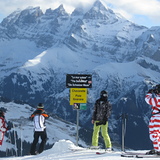
If you are looking for a totally ski in/out experience, with short airport transfers, then you cannot go wrong with a visit to Avoriaz. Nightlife and apres is limited, as it is a very family focused resort. But there is still a great buzz and ambience with music pumping out at La Folie Douce, which is pretty central and within staggering or skiing distance to all residencies. You will not be disappointed with the ski coverage on the Portes du Soleil lift pass, that takes you into Switzerland. Snow conditions have always been perfect when I have visited. Usually big dumps before I arrive and clear blue skies for my week. I think this may be sheer luck. Eating and drinking out is what it is .. you are in France. Although this year I have booked into the Club Belambra Hotel on a fully inclusive deal. One of the very few hotels in this resort. Fingers crossed, it is worth it. No matter where you decide to go, happy and safe skiing to you all.
Liam da Ireland scrive:
If you are looking for a totally ski in/out experience, with short airport transfers, then you cannot go wrong with a visit to Avoriaz.
Nightlife and apres is limited, as it is a very family focused resort. But there is still a great buzz and ambience with music pumping out at La Folie Douce, which is pretty central and within staggering or skiing distance to all residencies.
You will not be disappointed with the ski coverage on the Portes du Soleil lift pass, that takes you into Switzerland.
Snow conditions have always been perfect when I have visited. Usually big dumps before I arrive and clear blue skies for my week. I think this may be sheer luck.
Eating and drinking out is what it is .. you are in France.
Although this year I have booked into the Club Belambra Hotel on a fully inclusive deal. One of the very few hotels in this resort. Fingers crossed, it is worth it.
No matter where you decide to go, happy and safe skiing to you all.


 Nearest