

Portillo Re-Opens To Guests Arriving By Helicopter
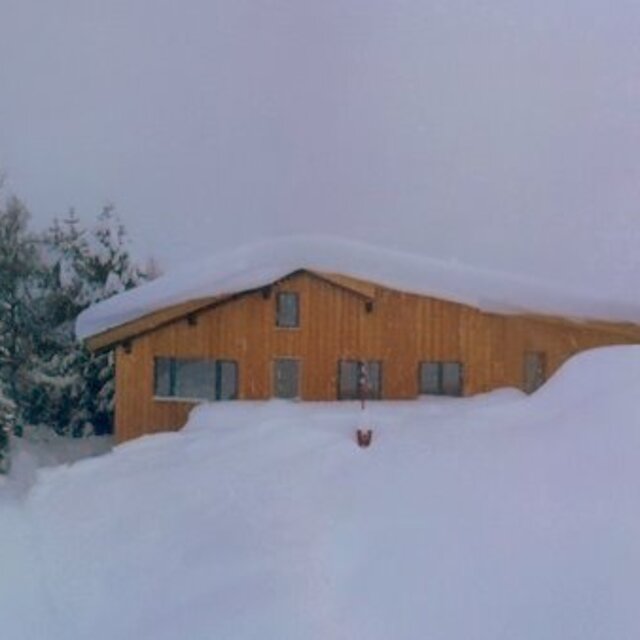
Chile’s famous Portillo ski resort is reported to have re-opened to guests arriving by helicopter after being cut off by road for more than two weeks by over 6m/20 feet of snowfall.

Next 3 days weather summary:Pioggia abbondante (totale 34.0mm), più pesante durante Mercoledì pomeriggio. Temperature moderate (max 11°C Martedì pomeriggio, min 8°C Mercoledì mattina). Vento sarà generalmente leggero. | Giorni 4-6 Andermatt sommario meteoPioggia abbondante (totale 29.0mm), più pesante durante Giovedì notte. Temperature moderate (max 9°C Giovedì mattina, min 6°C Giovedì notte). Vento sarà generalmente leggero. | |||||||||||||||||
Lunedì 3 | Martedì 4 | Mercoledì 5 | Giovedì 6 | Venerdì 7 | Sabato 8 | |||||||||||||
AM | PM | notte | AM | PM | notte | AM | PM | notte | AM | PM | notte | AM | PM | notte | AM | PM | notte | |
rischio temporale | rischio temporale | rovesci pioggia | rovesci pioggia | rischio temporale | rovesci pioggia | rovesci pioggia | rischio temporale | rovesci pioggia | rischio temporale | rovesci pioggia | rovesci pioggia | limpido | limpido | poche nuvole | limpido | rischio temporale | rovesci pioggia | |
km/h | ||||||||||||||||||
Mappa neve |  |  |  |  |  |  | ||||||||||||
— | — | — | — | — | — | — | — | — | — | — | — | — | — | — | — | — | — | |
mm | 3 | 5 | 6 | 1 | 1 | 4 | 1 | 7 | 6 | 1 | 10 | 16 | — | — | — | — | 1 | 1 |
max °C | 10 | 10 | 10 | 9 | 11 | 9 | 9 | 10 | 9 | 9 | 9 | 7 | 8 | 8 | 7 | 7 | 8 | 8 |
min °C | 10 | 10 | 9 | 9 | 10 | 9 | 8 | 10 | 9 | 9 | 8 | 6 | 7 | 7 | 7 | 7 | 8 | 8 |
chill °C | 10 | 9 | 6 | 7 | 9 | 8 | 7 | 10 | 9 | 8 | 7 | 6 | 7 | 7 | 7 | 6 | 8 | 8 |
Umido. % | 68 | 71 | 77 | 72 | 70 | 72 | 78 | 79 | 71 | 76 | 85 | 74 | 69 | 91 | 88 | 84 | 86 | 68 |
Zero termico m | 4450 | 4450 | 4400 | 4300 | 4500 | 4400 | 4350 | 4500 | 4400 | 4300 | 4300 | 4200 | 4100 | 4100 | 4150 | 4050 | 4150 | 4200 |
6:07 | — | — | 6:07 | — | — | 6:09 | — | — | 6:11 | — | — | 6:11 | — | — | 6:13 | — | — | |
— | — | 8:54 | — | — | 8:52 | — | — | 8:52 | — | — | 8:50 | — | — | 8:49 | — | — | 8:46 | |
Diventa pro e intaglia:
Informazioni valanghe: European Avalanche Warning Services (EAWS)
Gli ultimi report della neve vicino a Andermatt:
| La profondità maggiore della neve é: | 0 cm |
|---|---|
| La profondità minore della neve é: | 0 cm |
| Fresh snowfall depth: | — |
| Quando ha nevicato l'ultima volta? | 10 Jun 2026 |
0.1 | Giorni neve fresca Neve fresca, prevalentemente soleggiato, vento debole. |
|---|---|
0.1 | Giorni neve fresca Fresh snow, limited sun, any wind. |
0.1 | Giorni Bluebird Neve media, prevalentemente soleggiato, vento debole. |
La tabella sopra da le previsioni meteo per Andermatt a specifiche altezze 2963 m. I nostri sofisticati modelli meteo ci consentono di fornire previsioni neve per la vetta, l'area intermedia e a valle delle stazioni sciistiche di Andermatt. Per accedere alle previsioni meteo ad altre altezze, per spostarti usa tab sopra la tabella. Per una visione meteo piu' ampia , controlla la mappa meteo di Switzerland.
Clicca qui per leggere ulteriori informazioni sullo zero termico e il nostro sistema di prevedere le temperature.
Complessivamente 3.9 Basato su 24 voti e 15 recensioni
Wrote a report in 2008 and still going every year. So many changes but still a fantastic place to ski and walk in the valley and along the Rhone in the next valley. The lift system is now superb and there's usually no waiting for the lifts except at weekends. Good restaurants and cafes of all types. Returning in February to visit friends and the Gemsstock again
graham ellis da United Kingdom scrive:
Wrote a report in 2008 and still going every year.
So many changes but still a fantastic place to ski and walk in the valley and along the Rhone in the next valley.
The lift system is now superb and there's usually no waiting for the lifts except at weekends. Good restaurants and cafes of all types.
Returning in February to visit friends and the Gemsstock again


 Nearest