La tabella sopra da le previsioni meteo per Val Thorens a specifiche altezze 2765 m. I nostri sofisticati modelli meteo ci consentono di fornire previsioni neve per la vetta, l'area intermedia e a valle delle stazioni sciistiche di Val Thorens. Per accedere alle previsioni meteo ad altre altezze, per spostarti usa tab sopra la tabella. Per una visione meteo piu' ampia , controlla la mappa meteo di France.
Clicca qui per leggere ulteriori informazioni sullo zero termico e il nostro sistema di prevedere le temperature.
Recensioni dei visitatori di Val Thorens
Complessivamente 4.3 Basato su 79 voti e 44 recensioni
We visited Val Thorens 15th to 22nd February (half term) and had a fantastic holiday. We had a family group of 6, in a range of ages from 8 to 61. The ski resort has something for everyone. We were blessed with magnificent sunny weather and lots of snow.
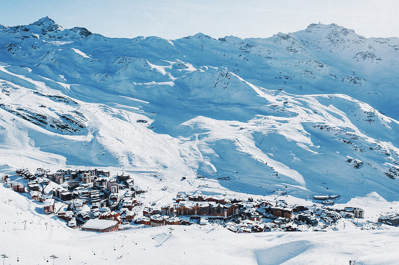
We stayed in Le Cheval Blanc apartments that are located right on the slopes, with operator Crystal Ski. The trip up from Chambery airport is long (over 3.5 hours), but once in VT that’s quickly forgotten. The big advantage of VT in these days of uncertain weather, is the elevation. With the village set at 2300m, the resort is very snow assured. From the apartments you can quickly travel to 3 adjacent high quality ski resorts - Les Menuires, Meribel and Courchevel. The lifts and facilities in all 4 resorts are modern with very efficient double access 6 man chair lifts.
The only slight challenge was the occasional long queue for the lifts but that was due to the half term holiday. But with over 500km of slopes to explore there are lots of quieter areas. I’d recommend parts of Les Menuires and the Orelle area. All in all, it’s a fantastic ski resort that won’t disappoint.
Complessivamente: 4.3 Basato su 79 voti e 44 recensioni
Snowsure
4.8
Varietà di piste
4.6
Fuoripista
4.5
Paesaggio
4.1
Apres-Ski
4.8
Guy da Austria scrive:
We visited Val Thorens 15th to 22nd February (half term) and had a fantastic holiday. We had a family group of 6, in a range of ages from 8 to 61. The ski resort has something for everyone. We were blessed with magnificent sunny weather and lots of snow.
We stayed in Le Cheval Blanc apartments that are located right on the slopes, with operator Crystal Ski. The trip up from Chambery airport is long (over 3.5 hours), but once in VT that’s quickly forgotten. The big advantage of VT in these days of uncertain weather, is the elevation. With the village set at 2300m, the resort is very snow assured. From the apartments you can quickly travel to 3 adjacent high quality ski resorts - Les Menuires, Meribel and Courchevel. The lifts and facilities in all 4 resorts are modern with very efficient double access 6 man chair lifts.
The only slight challenge was the occasional long queue for the lifts but that was due to the half term holiday. But with over 500km of slopes to explore there are lots of quieter areas. I’d recommend parts of Les Menuires and the Orelle area. All in all, it’s a fantastic ski resort that won’t disappoint.
Gratis Snow-Forecast.com weather widget per il tho sito
Il Val Thorens widget meteo qui sotto è disponibile per essere incorporato su siti Web esterni a titolo gratuito. Esso fornisce un riepilogo giornaliero delle nostre Val Thorens previsioni meteo neve e dati meteo. Basta andare alla pagina di configurazione e seguire 3 semplici passi per prendere il codice html personalizzato ed incollarlo nel tuo sito. È possibile scegliere l'elevazione di previsione di neve (vetta, metà o piede della montagna) e l'unità metrica/imperiale per le previsioni meteo neve adeguata al proprio sito Web Clicca qui per ottenere il codice


 Nearest