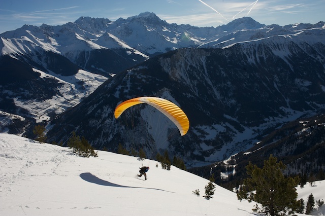


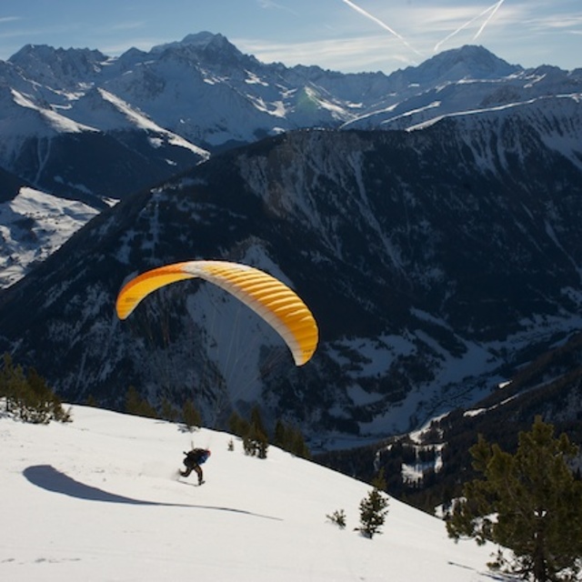
Portillo Storm Snowfall Total Passes 5m / 17 Feet
A snow storm that has now continued for nine days has taken Chilean ski resort Portillo to a snowfall total of 5.2 metres (17 feet) so far, with more snow forecast.

Next 3 days weather summary:Pioggia leggera (totale 5.0mm), per lo più che cade Martedì notte. Caldo (max 23°C Martedì pomeriggio, min 10°C Lunedì mattina). Vento sarà generalmente leggero. | Giorni 4-6 Champex-Lac sommario meteoPioggia moderata (totale 14.0mm), più pesante Sabato mattina. Caldo (max 27°C Venerdì pomeriggio, min 13°C Venerdì notte). Vento sarà generalmente leggero. | |||||||||||||||||
Lunedì 27 | Martedì 28 | Mercoledì 29 | Giovedì 30 | Venerdì 31 | Sabato 1 | |||||||||||||
AM | PM | notte | AM | PM | notte | AM | PM | notte | AM | PM | notte | AM | PM | notte | AM | PM | notte | |
poche nuvole | limpido | limpido | limpido | poche nuvole | rischio temporale | rischio temporale | rovesci pioggia | limpido | limpido | limpido | limpido | limpido | poche nuvole | rischio temporale | rischio temporale | rischio temporale | rovesci pioggia | |
km/h | ||||||||||||||||||
Mappa neve |  |  |  |  |  |  | ||||||||||||
— | — | — | — | — | — | — | — | — | — | — | — | — | — | — | — | — | — | |
mm | — | — | — | — | — | 3 | 1 | 1 | — | — | — | — | — | — | 5 | 5 | 3 | 1 |
max °C | 14 | 18 | 15 | 20 | 23 | 19 | 21 | 23 | 20 | 23 | 26 | 23 | 25 | 27 | 22 | 17 | 22 | 18 |
min °C | 10 | 17 | 11 | 14 | 23 | 14 | 17 | 23 | 15 | 19 | 25 | 17 | 19 | 27 | 13 | 14 | 20 | 13 |
chill °C | 10 | 17 | 11 | 14 | 23 | 14 | 17 | 23 | 15 | 19 | 25 | 17 | 19 | 27 | 13 | 14 | 20 | 13 |
Umido. % | 72 | 60 | 64 | 49 | 49 | 78 | 59 | 38 | 55 | 32 | 30 | 54 | 32 | 24 | 66 | 77 | 47 | 63 |
Zero termico m | 4150 | 4250 | 4700 | 4650 | 4700 | 4550 | 4400 | 4700 | 4700 | 4700 | 4850 | 4800 | 4800 | 4900 | 4700 | 4400 | 4550 | 4550 |
6:07 | — | — | 6:07 | — | — | 6:09 | — | — | 6:09 | — | — | 6:11 | — | — | 6:13 | — | — | |
— | — | 9:07 | — | — | 9:06 | — | — | 9:05 | — | — | 9:04 | — | — | 9:02 | — | — | 9:00 | |
Diventa pro e intaglia:
Informazioni valanghe: European Avalanche Warning Services (EAWS)
Gli ultimi report della neve vicino a Champex-Lac:
| La profondità maggiore della neve é: | — |
|---|---|
| La profondità minore della neve é: | — |
| Fresh snowfall depth: | — |
| Quando ha nevicato l'ultima volta? | 10 Jun 2026 |
0.0 | Giorni neve fresca Neve fresca, prevalentemente soleggiato, vento debole. |
|---|---|
0.0 | Giorni neve fresca Fresh snow, limited sun, any wind. |
0.0 | Giorni Bluebird Neve media, prevalentemente soleggiato, vento debole. |

La tabella sopra da le previsioni meteo per Champex-Lac a specifiche altezze 1702 m. I nostri sofisticati modelli meteo ci consentono di fornire previsioni neve per la vetta, l'area intermedia e a valle delle stazioni sciistiche di Champex-Lac. Per accedere alle previsioni meteo ad altre altezze, per spostarti usa tab sopra la tabella. Per una visione meteo piu' ampia , controlla la mappa meteo di Switzerland.
Clicca qui per leggere ulteriori informazioni sullo zero termico e il nostro sistema di prevedere le temperature.
Complessivamente 3.8 Basato su 3 voti e 5 recensioni
The comment about finding powder well after Verbier has lost its is correct. Also, if you have access to skins you will find super areas. Yes, the lifts are slow and yes, they are old but 45 mins from Verbier you can ski fresh powder all day and have a good meal to boot at 60% of Verbier prices. However, thank goodness that most people comming to Verbier has no access to skins or 4 wheel drives.
Martin Short da United Kingdom scrive:
The comment about finding powder well after Verbier has lost its is correct. Also, if you have access to skins you will find super areas. Yes, the lifts are slow and yes, they are old but 45 mins from Verbier you can ski fresh powder all day and have a good meal to boot at 60% of Verbier prices. However, thank goodness that most people comming to Verbier has no access to skins or 4 wheel drives.


 Nearest