
Freeride Added To 2030 Olympic Winter Games
The IOC has today announced a swathe of decisions ahead of the Alpes 2030 Winter Olympics and Paralympics in the French Alps.

Next 4 days weather summary:Temperato con pioggia (totale 11.0mm) Giovedì notte, Diventa più freddo con una leggera copertura di neve, che ancora cade Venerdì mattina. Condizioni di gelo e disgelo (max 5°C Giovedì pomeriggio, min -1°C Venerdì notte). Principalmente venti freschi. | Giorni 5-7 Chamonix sommario meteoPer lo più asciutto. Le temperature saranno sotto lo zero (max 0°C Sabato notte, min -3°C Martedì mattina). Vento sarà generalmente leggero. | |||||||||||||||
Giovedì 16 | Venerdì 17 | Sabato 18 | Domenica 19 | Lunedì 20 | ||||||||||||
notte | AM | PM | notte | AM | PM | notte | AM | PM | notte | AM | PM | notte | AM | PM | notte | |
rovesci pioggia | limpido | neve leggera | neve leggera | rovesci neve | limpido | rovesci neve | limpido | poche nuvole | limpido | poche nuvole | rovesci neve | limpido | poche nuvole | poche nuvole | limpido | |
km/h | ||||||||||||||||
Mappa neve |  |  |  |  |  |  | ||||||||||
— | — | 2 | 1 | 3 | — | 2 | — | — | — | — | — | — | — | — | — | |
mm | 4 | — | — | 6 | 1 | — | — | — | — | — | — | — | — | — | — | — |
max °C | 3 | 4 | 5 | 4 | 2 | 4 | 2 | -1 | 0 | 0 | -1 | 0 | 0 | 0 | 0 | 0 |
min °C | 2 | 3 | 2 | 1 | 2 | 3 | -1 | -1 | -1 | -1 | -2 | -1 | 0 | 0 | 0 | -1 |
chill °C | -4 | -3 | -4 | -6 | -4 | -3 | -7 | -7 | -6 | -7 | -8 | -7 | -5 | -6 | -6 | -7 |
Umido. % | 66 | 47 | 83 | 68 | 57 | 64 | 72 | 73 | 74 | 59 | 74 | 68 | 36 | 72 | 69 | 34 |
Zero termico m | 4200 | 4400 | 4100 | 4300 | 4200 | 4350 | 3850 | 3600 | 3850 | 3750 | 3600 | 3800 | 3900 | 3800 | 3900 | 3750 |
— | 5:56 | — | — | 5:58 | — | — | 5:58 | — | — | 6:00 | — | — | 6:01 | — | — | |
— | — | — | 9:19 | — | — | 9:17 | — | — | 9:16 | — | — | 9:15 | — | — | 9:15 | |
Diventa pro e intaglia:
Informazioni valanghe: European Avalanche Warning Services (EAWS)
Gli ultimi report della neve vicino a Chamonix:
| La profondità maggiore della neve é: | — |
|---|---|
| La profondità minore della neve é: | — |
| Fresh snowfall depth: | — |
| Quando ha nevicato l'ultima volta? | 10 Jun 2026 |
0.5 | Giorni neve fresca Neve fresca, prevalentemente soleggiato, vento debole. |
|---|---|
0.9 | Giorni neve fresca Fresh snow, limited sun, any wind. |
0.7 | Giorni Bluebird Neve media, prevalentemente soleggiato, vento debole. |
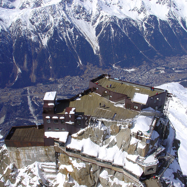
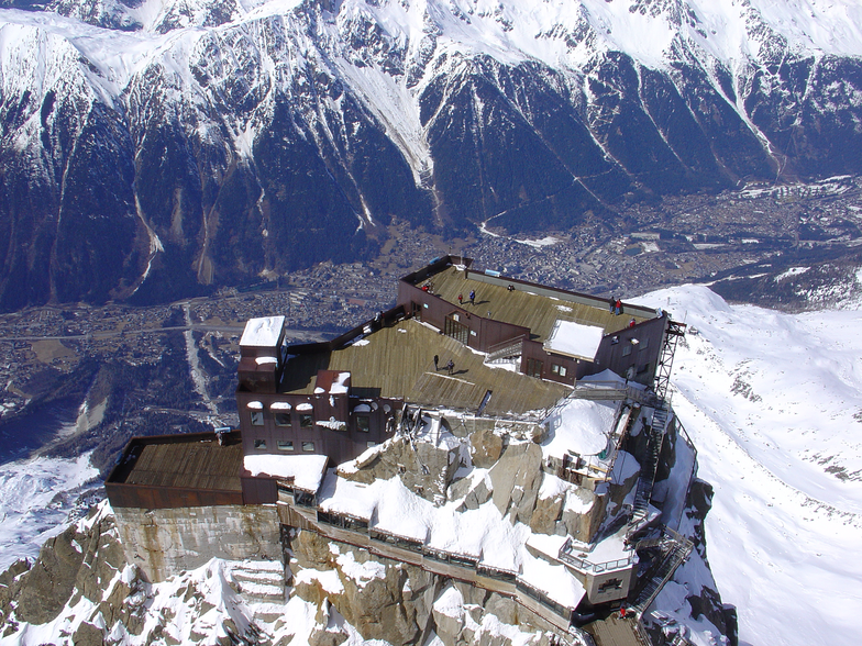
La tabella sopra da le previsioni meteo per Chamonix a specifiche altezze 3842 m. I nostri sofisticati modelli meteo ci consentono di fornire previsioni neve per la vetta, l'area intermedia e a valle delle stazioni sciistiche di Chamonix. Per accedere alle previsioni meteo ad altre altezze, per spostarti usa tab sopra la tabella. Per una visione meteo piu' ampia , controlla la mappa meteo di France.
Clicca qui per leggere ulteriori informazioni sullo zero termico e il nostro sistema di prevedere le temperature.
Complessivamente 4.1 Basato su 56 voti e 92 recensioni
I have been going to Chamonix for several years now, both winter and summer, and it just gets better and better. The thing about Chamonix is not only does it have world class skiing, but it is a bustling beautiful town that has a huge array of bars and restaurants, fantastic varied accommodation and fabulous shops. I like to experience different resorts across Europe but whilst skiing may be great, the off-piste can be limiting and you will only go once. With Chamonix (and a few other bigger resorts) you get an ever changing resort, suitable to budgets of all sizes and plenty to do for non-skiers too. The summer there is also just as good as the winter! If you want a purpose built ski-in / ski-out ski resort, then Chamonix is not for you. If you want the original and authentic ski town, then I can't recommend enough..
Spencer da United Kingdom scrive:
I have been going to Chamonix for several years now, both winter and summer, and it just gets better and better. The thing about Chamonix is not only does it have world class skiing, but it is a bustling beautiful town that has a huge array of bars and restaurants, fantastic varied accommodation and fabulous shops. I like to experience different resorts across Europe but whilst skiing may be great, the off-piste can be limiting and you will only go once. With Chamonix (and a few other bigger resorts) you get an ever changing resort, suitable to budgets of all sizes and plenty to do for non-skiers too. The summer there is also just as good as the winter! If you want a purpose built ski-in / ski-out ski resort, then Chamonix is not for you. If you want the original and authentic ski town, then I can't recommend enough..


 Nearest