
Ski Hire by Skiset
extra 5% off


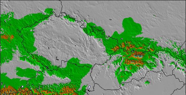
Waidring Weather (Next 3 days): The snow forecast for Waidring is: Una pesante caduta di neve, più pesante durante Venerdì notte. Le temperature saranno sotto lo zero (max -1°C Venerdì notte, min -5°C Lunedì mattina). Vento sarà generalmente leggero.
Waidring Weather (Days 4-6): Una leggera copertura di neve nuova Mercoledì mattina comincia a piovigginare Giovedì pomeriggio. Condizioni di gelo e disgelo (max 5°C Giovedì pomeriggio, min -4°C Martedì mattina). Vento sarà generalmente leggero.
| Altezza | Spessore della neve | Temp. (°C) | Vento (km/h) | Meteo | ||
|---|---|---|---|---|---|---|
| Cima: | -4 | |||||
| Media: | -1 | |||||
| Fondo: | 2 |
Gli ultimi report della neve vicino a Waidring:
Continuous moderate rain reported from Lofer at 622 metres elevation one km E of Lofer but it is forecast cold enough for snow at higher elevations in the ski area da Lofer
Light rain reported from Schwendt wx at 845 metres elevation only 4 kms N of Pillersee-Hochfilzen/Buchensteinwand but it is forecast cold enough for snow at higher elevations in the ski area da Pillersee-Hochfilzen/Buchensteinwand
Intermittent light rain reported from Lofer at 622 metres elevation one km E of Lofer but it is forecast cold enough for snow at higher elevations in the ski area da Lofer

Saturday 20 | Sunday 21 | Monday 22 | Tuesday 23 | Wednesday 24 | Thursday 25 | ||||||||||||||
notte | AM | PM | notte | AM | PM | notte | AM | PM | notte | AM | PM | notte | AM | PM | notte | AM | PM | notte | |
forte nevicata | nevi cata leggera | nevi cata leggera | nevi cata leggera | nevi cata leggera | nevi cata leggera | nevi cata leggera | rovescio di neve | nevi cata leggera | nevi cata leggera | nevi cata leggera | nevi cata leggera | nevi cata leggera | nevi cata leggera | nevi cata leggera | nevi cata leggera | poche nuvole | pioggia leggera | nevi cata leggera | |
km/h | |||||||||||||||||||
Snow map |  |  |  |  |  |  |  | ||||||||||||
cm | 11 | 4 | 3 | 4 | — | 1.0 | — | — | — | — | 1.0 | 1.0 | 2.0 | 1.0 | 1.0 | — | — | — | 4 |
mm | — | — | — | — | — | — | — | — | — | — | — | — | — | — | — | — | — | 1.0 | — |
max°C | -1 | -3 | -2 | -3 | -3 | -2 | -2 | -3 | -1 | -1 | -3 | -1 | -1 | -2 | 0 | 0 | 1 | 5 | 2 |
min°C | -3 | -3 | -3 | -4 | -4 | -2 | -4 | -5 | -2 | -3 | -4 | -2 | -2 | -3 | 0 | -2 | -1 | 4 | 0 |
chill°C | -8 | -8 | -8 | -4 | -4 | -5 | -6 | -5 | -5 | -3 | -6 | -5 | -4 | -7 | -3 | -2 | -1 | 4 | 0 |
Umido.% | 99 | 97 | 96 | 94 | 92 | 85 | 84 | 84 | 78 | 85 | 95 | 86 | 98 | 91 | 76 | 80 | 75 | 76 | 99 |
Zero termico (m) | 1150 | 900 | 1000 | 700 | 950 | 1100 | 0 | 900 | 1200 | 650 | 950 | 1200 | 1050 | 1100 | 1400 | 1100 | 1450 | 1950 | 1400 |
— | 6:11 | — | — | 6:09 | — | — | 6:07 | — | — | 6:05 | — | — | 6:03 | — | — | 6:01 | — | — | |
— | — | — | 8:06 | — | — | 8:07 | — | — | 8:08 | — | — | 8:10 | — | — | 8:12 | — | — | 8:13 | |
Una pesante caduta di neve, più pesante durante Venerdì notte. Le temperature saranno sotto lo zero (max -1°C Venerdì notte, min -5°C Lunedì mattina). Vento sarà generalmente leggero.
Una leggera copertura di neve nuova Mercoledì mattina comincia a piovigginare Giovedì pomeriggio. Condizioni di gelo e disgelo (max 5°C Giovedì pomeriggio, min -4°C Martedì mattina). Vento sarà generalmente leggero.
Gli ultimi report della neve vicino a Waidring:
Continuous moderate rain reported from Lofer at 622 metres elevation one km E of Lofer but it is forecast cold enough for snow at higher elevations in the ski area da Lofer
Light rain reported from Schwendt wx at 845 metres elevation only 4 kms N of Pillersee-Hochfilzen/Buchensteinwand but it is forecast cold enough for snow at higher elevations in the ski area da Pillersee-Hochfilzen/Buchensteinwand
Intermittent light rain reported from Lofer at 622 metres elevation one km E of Lofer but it is forecast cold enough for snow at higher elevations in the ski area da Lofer
| La profondità maggiore della neve é: | — |
|---|---|
| La profondità minore della neve é: | — |
| Fresh snowfall depth: | 19 cm |
| Quando ha nevicato l'ultima volta? | 18 Apr 2024 |
0.1 | Giorni neve fresca Neve fresca, prevalentemente soleggiato, vento debole. |
|---|---|
0.5 | Giorni neve fresca Fresh snow, limited sun, any wind. |
0.1 | Giorni Bluebird Neve media, prevalentemente soleggiato, vento debole. |
La tabella sopra da le previsioni meteo per Waidring a specifiche altezze 1340 m. I nostri sofisticati modelli meteo ci consentono di fornire previsioni neve per la vetta, l'area intermedia e a valle delle stazioni sciistiche di Waidring. Per accedere alle previsioni meteo ad altre altezze, per spostarti usa tab sopra la tabella. Per una visione meteo piu' ampia , controlla la mappa meteo di Austria.
Clicca qui per leggere ulteriori informazioni sullo zero termico e il nostro sistema di prevedere le temperature.
Complessivamente 3.9 Basato su 5 voti e 3 recensioni
Skied here several times, during Feb/March, as the snow was so much better than most other resorts, in the region, this year but it was often very busy because of this. Steinplatte is a great area for blue run skiers and there are some runs where even the most timid of skiers can allow their skis to stay in the foreline. The slopes are very wide and the lifts are very modern. As a consequence, when it is busy you really have to watch your back as there can be a large number of technically poor skiers hammering down the hill and it is sometimes quite dangerous to finish your turns because of the risk of someone skiing into you from behind. On quieter days, weekdays in January and just before Easter it is an intermediates paradise. If it gets too busy or the visibility is poor you can ski down to Winklmoos, in Germany, and usually avoid the queues and ski on tree-lined runs. This has the best terrain I have ever seen for beginners and very timid skiers afraid of any gradient, and holds the snow very well. Pros: incredible terrain for timid skiers, usually the best snow conditions in the area, fast efficient lift system, easy to get to by car. Cons: often very busy, a lot of idiot skiers, during the holidays, skiing too fast for their ability, not enough mountain restaurants which can get over-crowded, prone to misty whiteout conditions (most of the skiing is above the tree line). Top tip: always ski here on a sunny weekday in low season.
Mark Gunston da United Kingdom scrive:
Skied here several times, during Feb/March, as the snow was so much better than most other resorts, in the region, this year but it was often very busy because of this. Steinplatte is a great area for blue run skiers and there are some runs where even the most timid of skiers can allow their skis to stay in the foreline. The slopes are very wide and the lifts are very modern. As a consequence, when it is busy you really have to watch your back as there can be a large number of technically poor skiers hammering down the hill and it is sometimes quite dangerous to finish your turns because of the risk of someone skiing into you from behind. On quieter days, weekdays in January and just before Easter it is an intermediates paradise. If it gets too busy or the visibility is poor you can ski down to Winklmoos, in Germany, and usually avoid the queues and ski on tree-lined runs. This has the best terrain I have ever seen for beginners and very timid skiers afraid of any gradient, and holds the snow very well.
Pros: incredible terrain for timid skiers, usually the best snow conditions in the area, fast efficient lift system, easy to get to by car.
Cons: often very busy, a lot of idiot skiers, during the holidays, skiing too fast for their ability, not enough mountain restaurants which can get over-crowded, prone to misty whiteout conditions (most of the skiing is above the tree line).
Top tip: always ski here on a sunny weekday in low season.
Il Waidring widget meteo qui sotto è disponibile per essere incorporato su siti Web esterni a titolo gratuito. Esso fornisce un riepilogo giornaliero delle nostre Waidring previsioni meteo neve e dati meteo. Basta andare alla pagina di configurazione e seguire 3 semplici passi per prendere il codice html personalizzato ed incollarlo nel tuo sito. È possibile scegliere l'elevazione di previsione di neve (vetta, metà o piede della montagna) e l'unità metrica/imperiale per le previsioni meteo neve adeguata al proprio sito Web Clicca qui per ottenere il codice
Guarda previsioni meteo neve dettagliate per Waidring a:
snow-forecast.com


 Nearest