

Global Weekly Snow Roundup #314
Weekly Global Snow News, updated 14 May 2026: Fresh snowfall in Argentina, Australia and Lesotho signals winter’s approach, while Japan maintains the world’s deepest snowpack.

Next 3 days weather summary:Pioggia moderata (totale 15.0mm), più pesante Lunedì pomeriggio. Condizioni di gelo e disgelo (max 7°C Domenica pomeriggio, min -2°C Sabato notte). Vento sarà generalmente leggero. | Days 4-6 weather summary:Pioggia abbondante (totale 22.0mm), più pesante durante Mercoledì pomeriggio. Temperature moderate (max 14°C Giovedì pomeriggio, min 6°C Martedì mattina). Vento sarà generalmente leggero. | |||||||||||||||||
Saturday 16 | Sunday 17 | Monday 18 | Tuesday 19 | Wednesday 20 | Thursday 21 | |||||||||||||
AM | PM | notte | AM | PM | notte | AM | PM | notte | AM | PM | notte | AM | PM | notte | AM | PM | notte | |
nevi cata leggera | rovescio di pioggia | limpido | limpido | rovescio di pioggia | rovescio di pioggia | pioggia leggera | pioggia leggera | pioggia leggera | pioggia leggera | pioggia leggera | pioggia leggera | pioggia leggera | rischio temporale | rovescio di pioggia | poche nuvole | pioggia leggera | rovescio di pioggia | |
km/h | ||||||||||||||||||
Snow map |  |  |  |  |  |  | ||||||||||||
— | — | — | — | — | — | — | — | — | — | — | — | — | — | — | — | — | — | |
1 | 2 | — | — | 1 | 1 | 2 | 5 | 3 | 1 | 2 | 3 | 1 | 7 | 4 | — | 2 | 2 | |
max °C | 3 | 4 | 3 | 5 | 7 | 5 | 7 | 7 | 6 | 8 | 10 | 8 | 9 | 11 | 9 | 12 | 14 | 12 |
min °C | 1 | 4 | -2 | 2 | 7 | 2 | 5 | 7 | 5 | 6 | 10 | 7 | 8 | 11 | 6 | 8 | 14 | 7 |
-2 | 2 | -5 | 2 | 7 | 2 | 5 | 6 | 5 | 6 | 10 | 7 | 8 | 11 | 4 | 7 | 14 | 6 | |
79 | 76 | 78 | 64 | 72 | 92 | 78 | 87 | 89 | 75 | 74 | 90 | 77 | 74 | 83 | 55 | 48 | 78 | |
1900 | 2100 | 1200 | 2200 | 2400 | 2000 | 2400 | 2550 | 2350 | 2500 | 2800 | 2700 | 2800 | 2950 | 2850 | 2950 | 3300 | 3100 | |
5:37 | — | — | 5:35 | — | — | 5:35 | — | — | 5:33 | — | — | 5:33 | — | — | 5:31 | — | — | |
— | — | 8:38 | — | — | 8:39 | — | — | 8:40 | — | — | 8:42 | — | — | 8:43 | — | — | 8:45 | |
Gli ultimi report della neve vicino a Alleghe:
Moderate snow reported from Rolle Pass at 2083 metres elevation only 2 kms S of Passo Rolle Ski Resort da Passo Rolle
Moderate snow reported from Rolle Pass Airport at 2083 metres elevation only 2 kms S of Passo Rolle Ski Resort da Passo Rolle
| La profondità maggiore della neve é: | — |
|---|---|
| La profondità minore della neve é: | — |
| Fresh snowfall depth: | 15 cm |
| Quando ha nevicato l'ultima volta? | 15 May 2026 |
0.0 | Giorni neve fresca Neve fresca, prevalentemente soleggiato, vento debole. |
|---|---|
0.0 | Giorni neve fresca Fresh snow, limited sun, any wind. |
0.0 | Giorni Bluebird Neve media, prevalentemente soleggiato, vento debole. |

La tabella sopra da le previsioni meteo per Alleghe a specifiche altezze 1550 m. I nostri sofisticati modelli meteo ci consentono di fornire previsioni neve per la vetta, l'area intermedia e a valle delle stazioni sciistiche di Alleghe. Per accedere alle previsioni meteo ad altre altezze, per spostarti usa tab sopra la tabella. Per una visione meteo piu' ampia , controlla la mappa meteo di Italy.
Clicca qui per leggere ulteriori informazioni sullo zero termico e il nostro sistema di prevedere le temperature.
Complessivamente 3.7 Basato su 20 voti e 4 recensioni
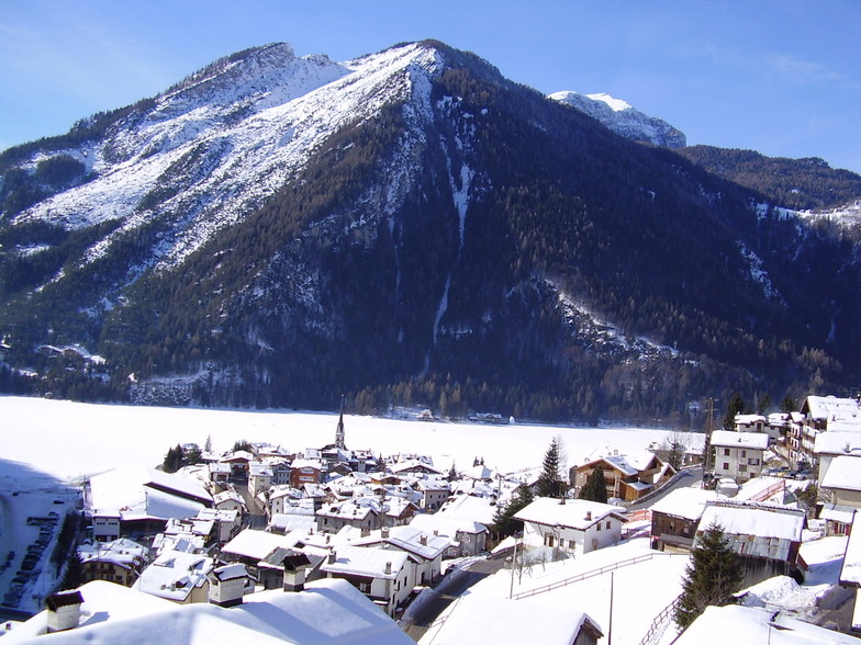
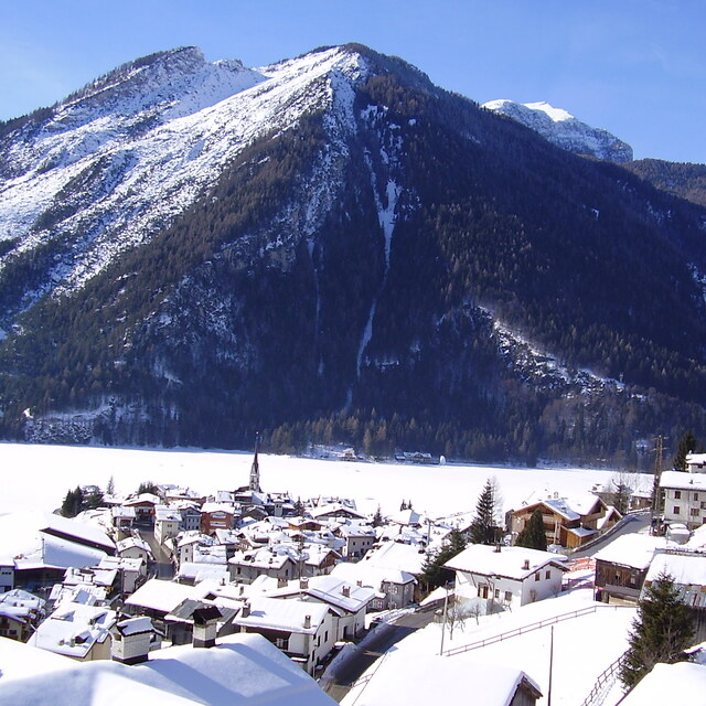
Alleghe è un piccolo villaggio Ladino ai piedi del Monte Civetta 3218 m la seconda montagna più alta dopo la Marmolada 3343 m . Un bellissimo lago alpino naturale formatosi 300 anni fa al centro della valle. Meta turistica estiva per scalatori alpinisti e camminatori tra i rifugi della München Venedig e dell' Alta Via 1 Dolomiti, paradiso per i bikers freerider e amanti dei percorsi del Giro d' Italia.In inverno sciatori e snowboarder nel comprensorio sciistico più grande al mondo Dolomiti Superski sono clienti fissi da novembre ad aprile su oltre 80 km di piste.Solamente 2 ore da Venezia ed altrettante 2 ore 30 da Innsbruck. In zona oltre al servizio autobus il servizio Taxi Alleghe Dolomites Company.
Gian Luca da Italy scrive:
Alleghe è un piccolo villaggio Ladino ai piedi del Monte Civetta 3218 m la seconda montagna più alta dopo la Marmolada 3343 m . Un bellissimo lago alpino naturale formatosi 300 anni fa al centro della valle. Meta turistica estiva per scalatori alpinisti e camminatori tra i rifugi della München Venedig e dell' Alta Via 1 Dolomiti, paradiso per i bikers freerider e amanti dei percorsi del Giro d' Italia.In inverno sciatori e snowboarder nel comprensorio sciistico più grande al mondo Dolomiti Superski sono clienti fissi da novembre ad aprile su oltre 80 km di piste.Solamente 2 ore da Venezia ed altrettante 2 ore 30 da Innsbruck. In zona oltre al servizio autobus il servizio Taxi Alleghe Dolomites Company.


 Nearest