
Ski Hire by Skiset
extra 5% off

Seefeld-Reith/Gschwandtkopf Weather (Next 3 days): The snow forecast for Seefeld-Reith/Gschwandtkopf is: Una moderata caduta di neve, concentrandosi maggiormente Mercoledì pomeriggio. Le temperature saranno sotto lo zero (max 0°C Martedì notte, min -7°C Mercoledì notte). Vento sarà generalmente leggero.
Seefeld-Reith/Gschwandtkopf Weather (Days 4-6): Una pesante caduta di neve, più pesante durante Venerdì notte. Le temperature saranno sotto lo zero (max -1°C Venerdì notte, min -5°C Sabato notte). Vento sarà generalmente leggero.
| Altezza | Spessore della neve | Temp. (°C) | Vento (km/h) | Meteo | ||
|---|---|---|---|---|---|---|
| Cima: | 0.0 m | -2 | ||||
| Fondo: | 0.0 m | 0 |
Gli ultimi report della neve vicino a Seefeld-Reith/Gschwandtkopf:
Light rain showers reported from Reutte at 843 metres elevation one km N of Reuttener Seilbahnen but it is forecast cold enough for snow at higher elevations in the ski area da Reuttener Seilbahnen
Freezing rain reported from Zugspitze at 2337 metres elevation one km S of Garmisch-Partenkirchen-Zugspitze but it is forecast cold enough for snow at the ski area da Garmisch-Partenkirchen-Zugspitze
Rain reported from Reutte at 843 metres elevation one km N of Reuttener Seilbahnen but it is forecast cold enough for snow at higher elevations in the ski area da Reuttener Seilbahnen
Rain reported from Seefeld at 1204 metres elevation only 2 kms ESE of Birkenlift but it is forecast cold enough for snow at higher elevations in the ski area da Birkenlift

Wednesday 17 | Thursday 18 | Friday 19 | Saturday 20 | Sunday 21 | Monday 22 | ||||||||||||||
notte | AM | PM | notte | AM | PM | notte | AM | PM | notte | AM | PM | notte | AM | PM | notte | AM | PM | notte | |
nevi cata leggera | nevi cata leggera | nevi cata leggera | rovescio di neve | nevi cata leggera | nevi cata leggera | nevi cata leggera | nuvol- oso | nevi cata leggera | nevi cata mod. | nevi cata leggera | nevi cata leggera | nevi cata mod. | nevi cata leggera | nevi cata leggera | nevi cata leggera | nevi cata leggera | nevi cata leggera | nevi cata leggera | |
km/h | |||||||||||||||||||
Snow map |  |  |  |  |  |  |  | ||||||||||||
cm | 3 | 3 | 4 | 2.0 | — | 2.0 | 2.0 | — | 1.0 | 9 | 2.0 | 3 | 6 | 1.0 | 1.0 | 2.0 | 1.0 | 2.0 | 2.0 |
mm | — | — | — | — | — | — | — | — | — | — | — | — | — | — | — | — | — | — | — |
max°C | 0 | -1 | -1 | -3 | -2 | -1 | -4 | -1 | 0 | -1 | -2 | -1 | -2 | -3 | -2 | -3 | -2 | -1 | -3 |
min°C | -2 | -2 | -1 | -7 | -5 | -1 | -5 | -4 | -1 | -2 | -3 | -1 | -5 | -5 | -2 | -5 | -5 | -1 | -6 |
chill°C | -4 | -2 | -4 | -10 | -5 | -4 | -5 | -6 | -4 | -5 | -6 | -3 | -7 | -8 | -5 | -5 | -5 | -3 | -9 |
Umido.% | 95 | 89 | 87 | 90 | 80 | 79 | 95 | 75 | 90 | 98 | 84 | 88 | 98 | 81 | 76 | 94 | 78 | 82 | 90 |
Zero termico (m) | 1200 | 1300 | 1300 | 350 | 1250 | 1300 | 700 | 1350 | 1400 | 1200 | 1250 | 1350 | 850 | 1050 | 1250 | 650 | 1150 | 1300 | 350 |
— | 6:22 | — | — | 6:20 | — | — | 6:18 | — | — | 6:16 | — | — | 6:15 | — | — | 6:13 | — | — | |
— | — | — | 8:07 | — | — | 8:08 | — | — | 8:09 | — | — | 8:10 | — | — | 8:13 | — | — | 8:14 | |
Una moderata caduta di neve, concentrandosi maggiormente Mercoledì pomeriggio. Le temperature saranno sotto lo zero (max 0°C Martedì notte, min -7°C Mercoledì notte). Vento sarà generalmente leggero.
Una pesante caduta di neve, più pesante durante Venerdì notte. Le temperature saranno sotto lo zero (max -1°C Venerdì notte, min -5°C Sabato notte). Vento sarà generalmente leggero.
Gli ultimi report della neve vicino a Seefeld-Reith/Gschwandtkopf:
Light rain showers reported from Reutte at 843 metres elevation one km N of Reuttener Seilbahnen but it is forecast cold enough for snow at higher elevations in the ski area da Reuttener Seilbahnen
Freezing rain reported from Zugspitze at 2337 metres elevation one km S of Garmisch-Partenkirchen-Zugspitze but it is forecast cold enough for snow at the ski area da Garmisch-Partenkirchen-Zugspitze
Rain reported from Reutte at 843 metres elevation one km N of Reuttener Seilbahnen but it is forecast cold enough for snow at higher elevations in the ski area da Reuttener Seilbahnen
Rain reported from Seefeld at 1204 metres elevation only 2 kms ESE of Birkenlift but it is forecast cold enough for snow at higher elevations in the ski area da Birkenlift
| La profondità maggiore della neve é: | 0 cm |
|---|---|
| La profondità minore della neve é: | 0 cm |
| Fresh snowfall depth: | 3 cm |
| Quando ha nevicato l'ultima volta? | 10 Apr 2024 |
0.0 | Giorni neve fresca Neve fresca, prevalentemente soleggiato, vento debole. |
|---|---|
0.2 | Giorni neve fresca Fresh snow, limited sun, any wind. |
0.0 | Giorni Bluebird Neve media, prevalentemente soleggiato, vento debole. |


La tabella sopra da le previsioni meteo per Seefeld-Reith/Gschwandtkopf a specifiche altezze 1500 m. I nostri sofisticati modelli meteo ci consentono di fornire previsioni neve per la vetta, l'area intermedia e a valle delle stazioni sciistiche di Seefeld-Reith/Gschwandtkopf. Per accedere alle previsioni meteo ad altre altezze, per spostarti usa tab sopra la tabella. Per una visione meteo piu' ampia , controlla la mappa meteo di Austria.
Clicca qui per leggere ulteriori informazioni sullo zero termico e il nostro sistema di prevedere le temperature.
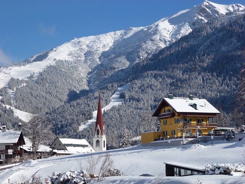
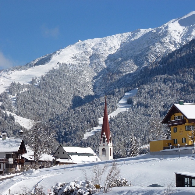
Il nome della localita' è scritto anche come Seefeld-Reith-Gschwandtkopf.
Complessivamente 4.0 Basato su 2 voti e 1 recensione
On the face of it Seefeld's second mountain has little to attract the diehard skier, but that would be to do the area a serious injustice! With a vertical of only 300m this puts the Geschwandtkopf on a par and scale with say Glenshee, but beyond that all the comparables end. Why? Because all the runs are north facing so are snow sure through the season, the pistes are all deserted, so very little if any ice and the mountain has two FIS rated race pistes which many national teams train and race on. Overall, the skiing is best suited to intermediates and beginners but advanced skiers will have a good day here too. Add to all of this the subline views of the Inn Valley and Seefeld plateau, the high quality and very reasonably priced Sportalm at the bottom, which is perfect for celebrity spotting (we saw Claudia Schiffer there one Sunday!) and the fact that Seefeld is one of the best all-round winter sports resort in the Alps and you have the perfect ingredients for a very enjoyable day or two as an alternative Seefeld's other ski area the Rosshutte. Recommended in small doses as part of a weeks stay in beautiful Seefeld.
Tirolerhund da United Kingdom scrive:
On the face of it Seefeld's second mountain has little to attract the diehard skier, but that would be to do the area a serious injustice!
With a vertical of only 300m this puts the Geschwandtkopf on a par and scale with say Glenshee, but beyond that all the comparables end. Why? Because all the runs are north facing so are snow sure through the season, the pistes are all deserted, so very little if any ice and the mountain has two FIS rated race pistes which many national teams train and race on.
Overall, the skiing is best suited to intermediates and beginners but advanced skiers will have a good day here too.
Add to all of this the subline views of the Inn Valley and Seefeld plateau, the high quality and very reasonably priced Sportalm at the bottom, which is perfect for celebrity spotting (we saw Claudia Schiffer there one Sunday!) and the fact that Seefeld is one of the best all-round winter sports resort in the Alps and you have the perfect ingredients for a very enjoyable day or two as an alternative Seefeld's other ski area the Rosshutte.
Recommended in small doses as part of a weeks stay in beautiful Seefeld.
Clicca qui per inviare la tua recensione di Seefeld-Reith/Gschwandtkopf
Il Seefeld-Reith/Gschwandtkopf widget meteo qui sotto è disponibile per essere incorporato su siti Web esterni a titolo gratuito. Esso fornisce un riepilogo giornaliero delle nostre Seefeld-Reith/Gschwandtkopf previsioni meteo neve e dati meteo. Basta andare alla pagina di configurazione e seguire 3 semplici passi per prendere il codice html personalizzato ed incollarlo nel tuo sito. È possibile scegliere l'elevazione di previsione di neve (vetta, metà o piede della montagna) e l'unità metrica/imperiale per le previsioni meteo neve adeguata al proprio sito Web Clicca qui per ottenere il codice
Guarda previsioni meteo neve dettagliate per Seefeld-Reith/Gschwandtkopf a:
snow-forecast.com


 Nearest