
Ski Lessons by SkiBro
BOOK NOW
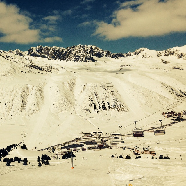
Ski lessons in Kühtai
Book now

Kühtai Weather (Next 3 days): The snow forecast for Kühtai is: Una moderata caduta di neve, concentrandosi maggiormente Domenica pomeriggio. Le temperature saranno sotto lo zero (max -9°C Lunedì pomeriggio, min -12°C Sabato notte). Vento sarà generalmente leggero.
Kühtai Weather (Days 4-6): Una moderata caduta di neve, concentrandosi maggiormente Martedì pomeriggio. Le temperature saranno sotto lo zero (max -8°C Giovedì pomeriggio, min -12°C Martedì mattina). Vento sarà generalmente leggero.
| Altezza | Spessore della neve | Temp. (°C) | Vento (km/h) | Meteo | ||
|---|---|---|---|---|---|---|
| Cima: | 0.0 m | -9 | ||||
| Media: | -7 | |||||
| Fondo: | 0.0 m | -6 |
Gli ultimi report della neve vicino a Kühtai:
Rain reported from Landeck at 785 metres elevation only 2 kms NW of Landeck-Zams-Fliess but it is forecast cold enough for snow at higher elevations in the ski area da Landeck-Zams-Fliess
Moderate rain reported from Flughafen Innsbruck Automatic Weather Station at 721 metres elevation 7 kms ENE of Oberperfuss but it is forecast cold enough for snow at higher elevations in the ski area da Oberperfuss
Light rain reported from Flughafen Innsbruck Automatic Weather Station at 721 metres elevation 5 kms WNW of Muttereralm but it is forecast cold enough for snow at higher elevations in the ski area da Muttereralm

Saturday 20 | Sunday 21 | Monday 22 | Tuesday 23 | Wednesday 24 | Thursday 25 | Friday 26 | |||||||||||||||
AM | PM | notte | AM | PM | notte | AM | PM | notte | AM | PM | notte | AM | PM | notte | AM | PM | notte | AM | PM | notte | |
nevi cata leggera | nevi cata leggera | nevi cata leggera | nuvol- oso | nevi cata mod. | nevi cata leggera | nevi cata leggera | nevi cata leggera | nevi cata leggera | nevi cata leggera | nevi cata leggera | nevi cata leggera | nevi cata leggera | nevi cata leggera | nevi cata leggera | nevi cata leggera | nevi cata leggera | rovescio di neve | poche nuvole | nevi cata leggera | nevi cata leggera | |
km/h | |||||||||||||||||||||
Snow map |  |  |  |  |  |  |  | ||||||||||||||
cm | 2.0 | 4 | 2.0 | — | 6 | 2.0 | — | 3 | 1.0 | 1.0 | 3 | 4 | 1.0 | 2.0 | 1.0 | — | 2.0 | 1.0 | — | — | — |
mm | — | — | — | — | — | — | — | — | — | — | — | — | — | — | — | — | — | — | — | — | — |
max°C | -10 | -10 | -11 | -10 | -10 | -11 | -10 | -9 | -10 | -11 | -10 | -10 | -11 | -10 | -10 | -10 | -8 | -8 | -6 | -4 | -3 |
min°C | -11 | -10 | -12 | -11 | -10 | -12 | -11 | -9 | -12 | -12 | -10 | -12 | -12 | -10 | -12 | -11 | -9 | -9 | -8 | -5 | -4 |
chill°C | -19 | -16 | -16 | -14 | -14 | -16 | -11 | -9 | -12 | -16 | -14 | -17 | -17 | -15 | -12 | -11 | -9 | -14 | -12 | -8 | -8 |
Umido.% | 90 | 93 | 80 | 79 | 94 | 87 | 92 | 95 | 96 | 93 | 90 | 97 | 88 | 87 | 88 | 85 | 86 | 96 | 80 | 90 | 71 |
Zero termico (m) | 1250 | 1250 | 250 | 1250 | 1100 | 550 | 1100 | 1300 | 650 | 1100 | 1300 | 900 | 1150 | 1300 | 600 | 1250 | 1550 | 800 | 1700 | 2050 | 1650 |
6:18 | — | — | 6:16 | — | — | 6:13 | — | — | 6:11 | — | — | 6:09 | — | — | 6:09 | — | — | 6:07 | — | — | |
— | — | 8:12 | — | — | 8:13 | — | — | 8:15 | — | — | 8:15 | — | — | 8:16 | — | — | 8:19 | — | — | 8:20 | |
Una moderata caduta di neve, concentrandosi maggiormente Domenica pomeriggio. Le temperature saranno sotto lo zero (max -9°C Lunedì pomeriggio, min -12°C Sabato notte). Vento sarà generalmente leggero.
Una moderata caduta di neve, concentrandosi maggiormente Martedì pomeriggio. Le temperature saranno sotto lo zero (max -8°C Giovedì pomeriggio, min -12°C Martedì mattina). Vento sarà generalmente leggero.
Gli ultimi report della neve vicino a Kühtai:
Rain reported from Landeck at 785 metres elevation only 2 kms NW of Landeck-Zams-Fliess but it is forecast cold enough for snow at higher elevations in the ski area da Landeck-Zams-Fliess
Moderate rain reported from Flughafen Innsbruck Automatic Weather Station at 721 metres elevation 7 kms ENE of Oberperfuss but it is forecast cold enough for snow at higher elevations in the ski area da Oberperfuss
Light rain reported from Flughafen Innsbruck Automatic Weather Station at 721 metres elevation 5 kms WNW of Muttereralm but it is forecast cold enough for snow at higher elevations in the ski area da Muttereralm
| La profondità maggiore della neve é: | 0 cm |
|---|---|
| La profondità minore della neve é: | 0 cm |
| Fresh snowfall depth: | 10 cm |
| Quando ha nevicato l'ultima volta? | 19 Apr 2024 |
0.4 | Giorni neve fresca Neve fresca, prevalentemente soleggiato, vento debole. |
|---|---|
2.0 | Giorni neve fresca Fresh snow, limited sun, any wind. |
1.0 | Giorni Bluebird Neve media, prevalentemente soleggiato, vento debole. |
La tabella sopra da le previsioni meteo per Kühtai a specifiche altezze 2520 m. I nostri sofisticati modelli meteo ci consentono di fornire previsioni neve per la vetta, l'area intermedia e a valle delle stazioni sciistiche di Kühtai. Per accedere alle previsioni meteo ad altre altezze, per spostarti usa tab sopra la tabella. Per una visione meteo piu' ampia , controlla la mappa meteo di Austria.
Clicca qui per leggere ulteriori informazioni sullo zero termico e il nostro sistema di prevedere le temperature.
Il nome della localita' è scritto anche come Kuehtai.
Complessivamente 4.0 Basato su 13 voti e 7 recensioni
Kuhtai is a small steep resort with limited blue run skiing. There are a couple of blues higher up the mountain but you have to ski down quite a steep red run to get back to base. There is no lift back option unless you're prepared to walk back up the slope to the gondola. Of course this is no problem for most skiers but learners and people lacking in confidence beware. I, on the other hand, am an experienced skier with a 6 year old lad that happens to be fearless so it's great. Hotel Elisabeth is great, on the slope, next to the lift. Kuhtai also has night skiing which is a great experience. It's only 40 mins from Innsbruck Airport, much cheaper than other resorts for ski pass, accommodation etc and is big enough for a small family and the less experienced. If you wish to venture further then you can catch a free bus to a resort down the road. The lift pass covers both resorts. The snow conditions are always good due to it being the highest resort in Austria and the slopes are always well groomed and quite. If you like off-piste then there's a great damm wall you can ski down plus other bits and pieces. There's also a fantastic toboggan run that's about 2 miles long where you can hire a sledge and get a lift. If you want value and quality but can live with a small resort and can ski then it's great. Let's face it, if you find a nice ski run in a large resort then sometimes it's better to ski the one you like rather than traipse from resort to resort and plan to get back on time or you can find yourself stuck in another valley facing a very expensive taxi back. All the ski runs are good and lead back to the main village. Throw the lift pass away and enjoy the slopes!
Jonathan Brook da United Kingdom scrive:
Kuhtai is a small steep resort with limited blue run skiing. There are a couple of blues higher up the mountain but you have to ski down quite a steep red run to get back to base. There is no lift back option unless you're prepared to walk back up the slope to the gondola. Of course this is no problem for most skiers but learners and people lacking in confidence beware. I, on the other hand, am an experienced skier with a 6 year old lad that happens to be fearless so it's great. Hotel Elisabeth is great, on the slope, next to the lift. Kuhtai also has night skiing which is a great experience. It's only 40 mins from Innsbruck Airport, much cheaper than other resorts for ski pass, accommodation etc and is big enough for a small family and the less experienced. If you wish to venture further then you can catch a free bus to a resort down the road. The lift pass covers both resorts. The snow conditions are always good due to it being the highest resort in Austria and the slopes are always well groomed and quite. If you like off-piste then there's a great damm wall you can ski down plus other bits and pieces. There's also a fantastic toboggan run that's about 2 miles long where you can hire a sledge and get a lift. If you want value and quality but can live with a small resort and can ski then it's great. Let's face it, if you find a nice ski run in a large resort then sometimes it's better to ski the one you like rather than traipse from resort to resort and plan to get back on time or you can find yourself stuck in another valley facing a very expensive taxi back. All the ski runs are good and lead back to the main village. Throw the lift pass away and enjoy the slopes!
Il Kühtai widget meteo qui sotto è disponibile per essere incorporato su siti Web esterni a titolo gratuito. Esso fornisce un riepilogo giornaliero delle nostre Kühtai previsioni meteo neve e dati meteo. Basta andare alla pagina di configurazione e seguire 3 semplici passi per prendere il codice html personalizzato ed incollarlo nel tuo sito. È possibile scegliere l'elevazione di previsione di neve (vetta, metà o piede della montagna) e l'unità metrica/imperiale per le previsioni meteo neve adeguata al proprio sito Web Clicca qui per ottenere il codice
Guarda previsioni meteo neve dettagliate per Kühtai a:
snow-forecast.com


 Nearest